|
|
|
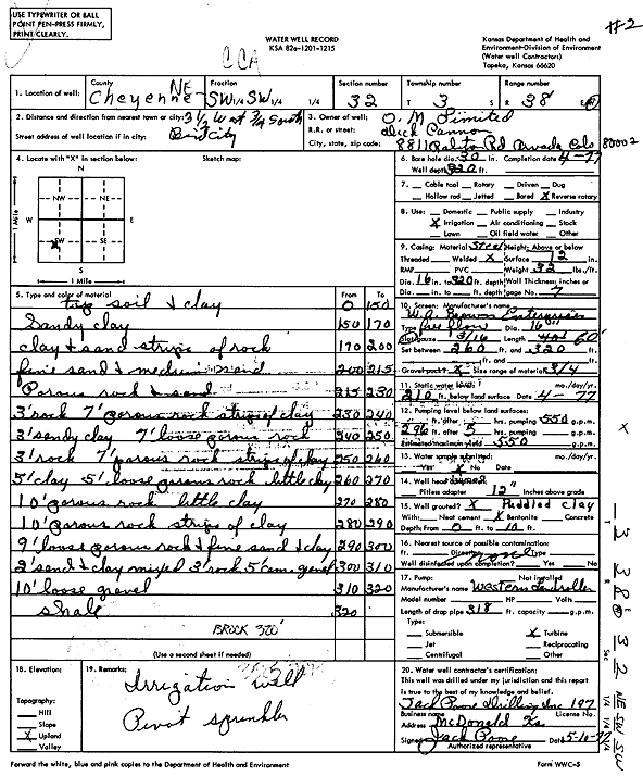
Specific Water Well Detail |
|
|
| Location Info | |||
| Owner: O.M. Limited | Status: Constructed | ||
| Location: T3S, R38W, Sec. 32, NE SW SW | County: Cheyenne | ||
| Directions: from Bird City, 3.5 mi W and 0.75 mi S | |||
| Latitude: 39.7450331 | Longitude: -101.6135075 | Datum NAD 27 | |
| Latitude: 39.7450277 | Longitude: -101.6139537 | Datum NAD 83 | |
| Longitude and latitude calculated by Survey from township-range-section-quarter calls. Only good to within the quarter call accuracy. | |||
| View well on interactive map | |||
| General Info | ||
| Well Depth: 320 ft. | Elevation: ft. | |
| Static Water Level: 210 ft. | Est. Yield: 550 gpm. | |
| Comp. Date: 01-Apr-1977 | Well Use: Irrigation | |
| DWR Applic. #: | Other ID: | |
| Links | |
| View info from Wizard Water Level Data base... | |
| View info from WIMAS Water Right Data base... | |
| Driller Info | ||
| Driller: Jack Poore Drilling Inc. | License #: 197 | |
| Scanned Form | View scan |
|
Chemical Sample Submitted?: No
Water Well disinfected?: | ||
| Ground water encountered: 0 ft. , 0 ft. , 0 ft. | ||
| Pump test data: Well water was 0 ft after 0 hours pumping 0 gpm | ||
| Casing Info | ||
| Casing Type:
Casing Joints: |
Diam: 0 in. to 0 ft
Diam: 0 in. to 0 ft Diam: 0 in. to 0 ft | |
| Casing height above land surface: in
Casing Weight: lbs/ft Wall thickness or gauge no.: | ||
| Screen and Perforation Info | ||
| Screen Type: | Screen Openings: | |
| Screen-perforated intervals | From: 262 ft to 20 ft
From: 0 ft to 0 ft From: 0 ft to 0 ft | |
| Gravel pack intervals | From: ft to ft | |
| Grout Info | ||
| Grout used: | From: 0 to 0 ft
From: 0 to 0 ft From: 0 to 0 ft | |
| Source of Possible Contamination | ||
| Source: | ||
| Direction from well: | Distance: 0 ft | |
| Lithologic Log
(Log data entered by KGS.) | ||
| From: 0 ft. to 150 ft. | top soil and clay | |
| From: 150 ft. to 170 ft. | sandy clay | |
| From: 170 ft. to 200 ft. | clay and sand strips of rock | |
| From: 200 ft. to 215 ft. | fine sand and medium sand | |
| From: 215 ft. to 230 ft. | porous rock and sand | |
| From: 230 ft. to 240 ft. | 3 feet rock 7 feet porous rock strips of clay | |
| From: 240 ft. to 250 ft. | 3 feet sandy clay 7 feet loose porous rock | |
| From: 250 ft. to 260 ft. | 3 feet rock 7 feet porous rock strips of clay | |
| From: 260 ft. to 270 ft. | 5 feet clay 5 feet loose porous rock little clay | |
| From: 270 ft. to 280 ft. | porous rock with little clay | |
| From: 280 ft. to 290 ft. | porous rock with strips of clay | |
| From: 290 ft. to 300 ft. | loose porous rock and fine sand and clay | |
| From: 300 ft. to 310 ft. | 2 feet sand and clay mixed 3 feet rock 5 feet coarse gravel | |
| From: 310 ft. to 320 ft. | loose gravel | |
| From: 320 ft. to ft. | shale | |