|
|
|
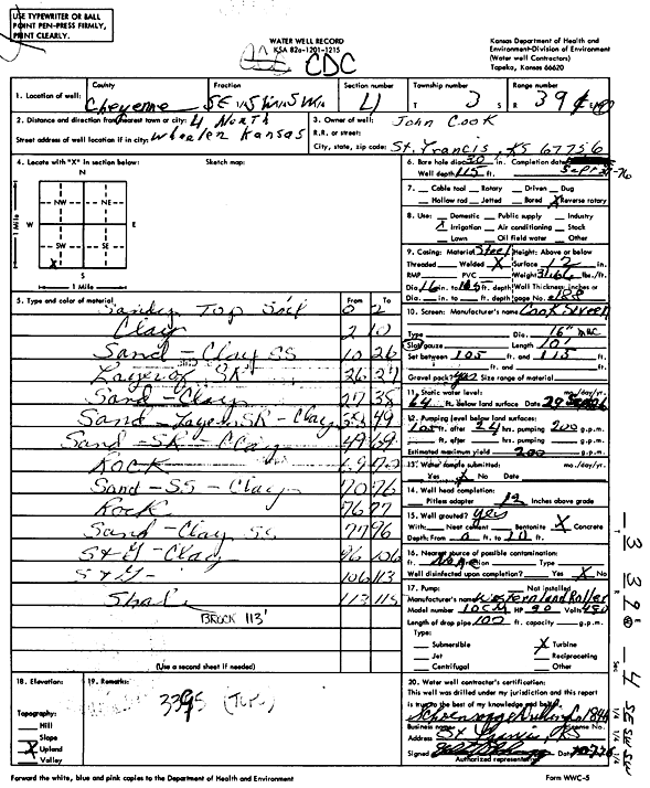
Specific Water Well Detail |
|
|
| Location Info | |||
| Owner: Cook, John | Status: Constructed | ||
| Location: T3S, R39W, Sec. 4, SE SW SW | County: Cheyenne | ||
| Directions: from Wheeler, 4 mi N | |||
| Latitude: 39.815383 | Longitude: -101.706708 | Datum NAD 27 | |
| Latitude: 39.8153764 | Longitude: -101.7071573 | Datum NAD 83 | |
| Longitude and latitude calculated by Survey from township-range-section-quarter calls. Only good to within the quarter call accuracy. | |||
| View well on interactive map | |||
| General Info | ||
| Well Depth: 115 ft. | Elevation: ft. | |
| Static Water Level: 64 ft. | Est. Yield: 200 gpm. | |
| Comp. Date: 27-Sep-1976 | Well Use: Irrigation | |
| DWR Applic. #: | Other ID: | |
| Links | |
| View info from Wizard Water Level Data base... | |
| View info from WIMAS Water Right Data base... | |
| Driller Info | ||
| Driller: Schoenrogge Drilling, Inc. | License #: 184 | |
| Scanned Form | View scan |
|
Chemical Sample Submitted?: No
Water Well disinfected?: | ||
| Ground water encountered: 0 ft. , 0 ft. , 0 ft. | ||
| Pump test data: Well water was 0 ft after 0 hours pumping 0 gpm | ||
| Casing Info | ||
| Casing Type:
Casing Joints: |
Diam: 0 in. to 0 ft
Diam: 0 in. to 0 ft Diam: 0 in. to 0 ft | |
| Casing height above land surface: in
Casing Weight: lbs/ft Wall thickness or gauge no.: | ||
| Screen and Perforation Info | ||
| Screen Type: | Screen Openings: | |
| Screen-perforated intervals | From: 105 ft to 115 ft
From: 0 ft to 0 ft From: 0 ft to 0 ft | |
| Gravel pack intervals | From: ft to ft | |
| Grout Info | ||
| Grout used: | From: 0 to 0 ft
From: 0 to 0 ft From: 0 to 0 ft | |
| Source of Possible Contamination | ||
| Source: | ||
| Direction from well: | Distance: 0 ft | |
| Lithologic Log
(Log data entered by KGS.) | ||
| From: 0 ft. to 2 ft. | Sandy topsoil | |
| From: 2 ft. to 10 ft. | Clay | |
| From: 10 ft. to 26 ft. | Sand, clay, sandstone | |
| From: 26 ft. to 27 ft. | Layer of sand rock | |
| From: 27 ft. to 38 ft. | Sand, clay | |
| From: 38 ft. to 49 ft. | Sand, layer of sand rock, clay | |
| From: 49 ft. to 69 ft. | Sand, sand rock, clay | |
| From: 69 ft. to 70 ft. | Rock | |
| From: 70 ft. to 76 ft. | Sand, sandstone, clay | |
| From: 76 ft. to 77 ft. | Rock | |
| From: 77 ft. to 96 ft. | Sand, clay, sandstone | |
| From: 96 ft. to 106 ft. | Sand and gravel, clay | |
| From: 106 ft. to 113 ft. | Sand and gravel | |
| From: 113 ft. to 115 ft. | Shale | |