|
|
|
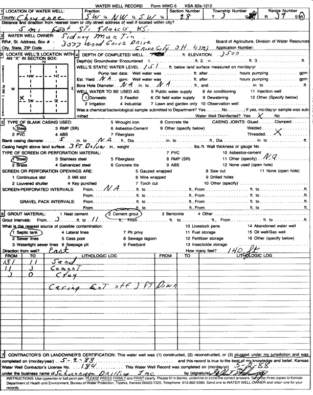
Specific Water Well Detail |
|
|
| Location Info | |||
| Owner: Martin, Sidney | Status: Plugged | ||
| Location: T3S, R39W, Sec. 28, SW NW SW | County: Cheyenne | ||
| Directions: from St. Francis, 5 mi E | |||
| Latitude: 39.7610888 | Longitude: -101.7098764 | Datum NAD 27 | |
| Latitude: 39.7610822 | Longitude: -101.7103257 | Datum NAD 83 | |
| Longitude and latitude calculated by Survey from township-range-section-quarter calls. Only good to within the quarter call accuracy. | |||
| View well on interactive map | |||
| General Info | ||
| Well Depth: 151 ft. | Elevation: 3500 ft. | |
| Static Water Level: ft. | Est. Yield: gpm. | |
| Comp. Date: 02-May-1988 | Well Use: Domestic | |
| DWR Applic. #: | Other ID: | |
| Driller Info | ||
| Driller: Schoenrogge Drilling, Inc. | License #: 184 | |
| Scanned Form | View scan |
| Casing Info | ||
|
Casing Type: Steel
Diam: 5 in. Casing height above land surface: in | ||
| Grout Info | ||
| Grout used: Cement grout | From: 3 to 11 ft
From: 0 to 0 ft From: 0 to 0 ft | |
| Source of Possible Contamination | ||
| Source: Septic Tank | ||
| Direction from well: | Distance: 0 ft | |