|
|
|
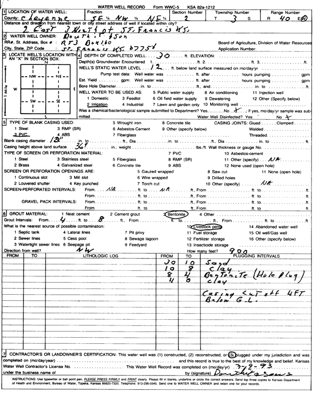
Specific Water Well Detail |
|
|
| Location Info | |||
| Owner: Douthit and Sons | Status: Plugged | ||
| Location: T3S, R40W, Sec. 2, SE NW NE | County: Cheyenne | ||
| Directions: from St. Francis, 2 mi E and 3 mi N | |||
| Latitude: 39.8262366 | Longitude: -101.7726518 | Datum NAD 27 | |
| Latitude: 39.8262294 | Longitude: -101.7731034 | Datum NAD 83 | |
| Longitude and latitude calculated by Survey from township-range-section-quarter calls. Only good to within the quarter call accuracy. | |||
| View well on interactive map | |||
| General Info | ||
| Well Depth: 30 ft. | Elevation: ft. | |
| Static Water Level: 12 ft. | Est. Yield: gpm. | |
| Comp. Date: 09-Mar-1993 | Well Use: Irrigation | |
| DWR Applic. #: | Other ID: | |
| Links | |
| View info from Wizard Water Level Data base... | |
| View info from WIMAS Water Right Data base... | |
| Driller Info | ||
| Driller: well owner | License #: | |
| Scanned Form | View scan |
| Casing Info | ||
|
Casing Type: PVC
Diam: 12 in. Casing height above land surface: in | ||
| Grout Info | ||
| Grout used: Bentonite | From: 4 to 8 ft
From: 0 to 0 ft From: 0 to 0 ft | |
| Source of Possible Contamination | ||
| Source: Livestock pens | ||
| Direction from well: | Distance: 0 ft | |