|
|
|
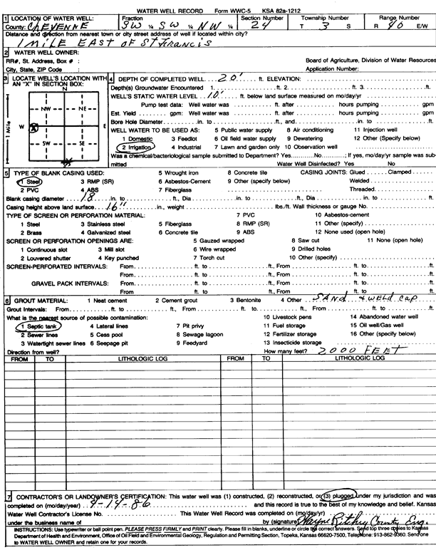
Specific Water Well Detail |
|
|
| Location Info | |||
| Owner: | Status: Plugged | ||
| Location: T3S, R40W, Sec. 24, SW SW NW | County: Cheyenne | ||
| Directions: from St. Francis, 1 mi E | |||
| Latitude: 39.7792307 | Longitude: -101.7661919 | Datum NAD 27 | |
| Latitude: 39.7792236 | Longitude: -101.7666432 | Datum NAD 83 | |
| Longitude and latitude calculated by Survey from township-range-section-quarter calls. Only good to within the quarter call accuracy. | |||
| View well on interactive map | |||
| General Info | ||
| Well Depth: 20 ft. | Elevation: ft. | |
| Static Water Level: 10 ft. | Est. Yield: gpm. | |
| Comp. Date: 14-Apr-1986 | Well Use: Irrigation | |
| DWR Applic. #: | Other ID: | |
| Links | |
| No Wizard information available. | |
| View info from WIMAS Water Right Data base... | |
| Driller Info | ||
| Driller: Cheyenne County | License #: | |
| Scanned Form | View scan |
| Casing Info | ||
|
Casing Type: Steel
Diam: 18 in. Casing height above land surface: in | ||
| Grout Info | ||
| Grout used: | From: 0 to 0 ft
From: 0 to 0 ft From: 0 to 0 ft | |
| Source of Possible Contamination | ||
| Source: Septic Tank | ||
| Direction from well: | Distance: 0 ft | |