|
|
|
Specific Water Well Detail |
|
|
| Location Info | |||
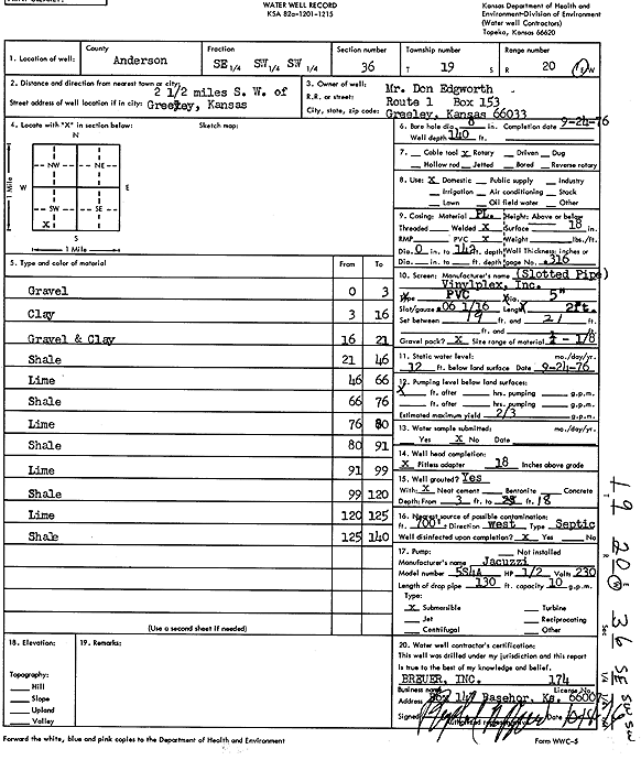
| Owner: Edgworth, Don | Status: Constructed | ||
| Location: T19S, R20E, Sec. 36, SE SW SW | County: Anderson | ||
| Directions: from Greeley: 2.5 mi SW | |||
| Latitude: 38.3472756 | Longitude: -95.1538224 | Datum NAD 27 | |
| Latitude: 38.3472956 | Longitude: -95.1540723 | Datum NAD 83 | |
| Longitude and latitude calculated by Survey from township-range-section-quarter calls. Only good to within the quarter call accuracy. | |||
| View well on interactive map | |||
| General Info | ||
| Well Depth: 140 ft. | Elevation: ft. | |
| Static Water Level: 12 ft. | Est. Yield: .67 gpm. | |
| Comp. Date: 24-Sep-1976 | Well Use: Domestic | |
| DWR Applic. #: | Other ID: | |
| Driller Info | ||
| Driller: Raphael Breuer, Inc. | License #: 174 | |
| Scanned Form | View scan |
|
Chemical Sample Submitted?: No
Water Well disinfected?: | ||
| Ground water encountered: 0 ft. , 0 ft. , 0 ft. | ||
| Pump test data: Well water was 0 ft after 0 hours pumping 0 gpm | ||
| Casing Info | ||
| Casing Type:
Casing Joints: |
Diam: 0 in. to 0 ft
Diam: 0 in. to 0 ft Diam: 0 in. to 0 ft | |
| Casing height above land surface: in
Casing Weight: lbs/ft Wall thickness or gauge no.: | ||
| Screen and Perforation Info | ||
| Screen Type: | Screen Openings: | |
| Screen-perforated intervals | From: 19 ft to 21 ft
From: 0 ft to 0 ft From: 0 ft to 0 ft | |
| Gravel pack intervals | From: ft to ft | |
| Grout Info | ||
| Grout used: | From: 0 to 0 ft
From: 0 to 0 ft From: 0 to 0 ft | |
| Source of Possible Contamination | ||
| Source: | ||
| Direction from well: | Distance: 0 ft | |
| Lithologic Log
(Log data entered by KGS.) | ||
| From: 0 ft. to 3 ft. | Gravel | |
| From: 3 ft. to 16 ft. | Clay | |
| From: 16 ft. to 21 ft. | Gravel and clay | |
| From: 21 ft. to 46 ft. | Shale | |
| From: 46 ft. to 66 ft. | Lime | |
| From: 66 ft. to 76 ft. | Shale | |
| From: 76 ft. to 80 ft. | Lime | |
| From: 80 ft. to 91 ft. | Shale | |
| From: 91 ft. to 99 ft. | Lime | |
| From: 99 ft. to 120 ft. | Shale | |
| From: 120 ft. to 125 ft. | Lime | |
| From: 125 ft. to 140 ft. | Shale | |