|
|
|
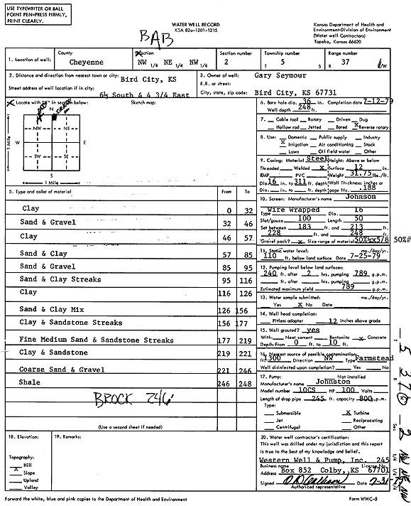
Specific Water Well Detail |
|
|
| Location Info | |||
| Owner: Seymour, Gary | Status: Constructed | ||
| Location: T5S, R37W, Sec. 2, NW NE NW | County: Cheyenne | ||
| Directions: from Bird City, 6.5 mi S and 4.75 mi E | |||
| Latitude: 39.6545414 | Longitude: -101.4431214 | Datum NAD 27 | |
| Latitude: 39.6545387 | Longitude: -101.4435634 | Datum NAD 83 | |
| Longitude and latitude calculated by Survey from township-range-section-quarter calls. Only good to within the quarter call accuracy. | |||
| View well on interactive map | |||
| General Info | ||
| Well Depth: 248 ft. | Elevation: ft. | |
| Static Water Level: 110 ft. | Est. Yield: 789 gpm. | |
| Comp. Date: 12-Jul-1979 | Well Use: Irrigation | |
| DWR Applic. #: | Other ID: | |
| Links | |
| No Wizard information available. | |
| View info from WIMAS Water Right Data base... | |
| Driller Info | ||
| Driller: Western Well & Pump, Inc. | License #: 245 | |
| Scanned Form | View scan |
|
Chemical Sample Submitted?: No
Water Well disinfected?: | ||
| Ground water encountered: 0 ft. , 0 ft. , 0 ft. | ||
| Pump test data: Well water was 0 ft after 0 hours pumping 0 gpm | ||
| Casing Info | ||
| Casing Type:
Casing Joints: |
Diam: 0 in. to 0 ft
Diam: 0 in. to 0 ft Diam: 0 in. to 0 ft | |
| Casing height above land surface: in
Casing Weight: lbs/ft Wall thickness or gauge no.: | ||
| Screen and Perforation Info | ||
| Screen Type: | Screen Openings: | |
| Screen-perforated intervals | From: 183 ft to 213 ft
From: 228 ft to 248 ft From: 0 ft to 0 ft | |
| Gravel pack intervals | From: ft to ft | |
| Grout Info | ||
| Grout used: | From: 0 to 0 ft
From: 0 to 0 ft From: 0 to 0 ft | |
| Source of Possible Contamination | ||
| Source: | ||
| Direction from well: | Distance: 0 ft | |
| Lithologic Log
(Log data entered by KGS.) | ||
| From: 0 ft. to 32 ft. | Clay | |
| From: 32 ft. to 46 ft. | Sand and gravel | |
| From: 46 ft. to 57 ft. | Clay | |
| From: 57 ft. to 85 ft. | Sand and clay | |
| From: 85 ft. to 95 ft. | Sand and gravel | |
| From: 95 ft. to 116 ft. | Sand and clay streaks | |
| From: 116 ft. to 126 ft. | Clay | |
| From: 126 ft. to 156 ft. | Sand and clay mix | |
| From: 156 ft. to 177 ft. | Clay and sandstone streaks | |
| From: 177 ft. to 219 ft. | Fine medium sand and sandstone streaks | |
| From: 219 ft. to 221 ft. | Clay and sandstone | |
| From: 221 ft. to 246 ft. | Coarse sand and gravel | |
| From: 246 ft. to 248 ft. | Shale | |