|
|
|
Specific Water Well Detail |
|
|
| Location Info | |||
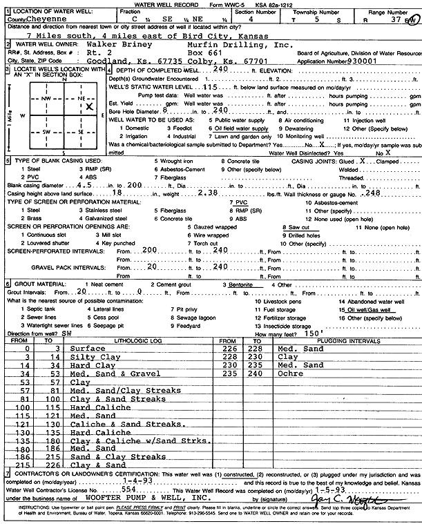
| Owner: Murfin Drilling/Walker Briney | Status: Constructed | ||
| Location: T5S, R37W, Sec. 4, C SE NE | County: Cheyenne | ||
| Directions: from Bird City, 7 mi S and 4 mi E | |||
| Latitude: 39.6499821 | Longitude: -101.4702356 | Datum NAD 27 | |
| Latitude: 39.6499793 | Longitude: -101.4706782 | Datum NAD 83 | |
| Longitude and latitude calculated by Survey from township-range-section-quarter calls. Only good to within the quarter call accuracy. | |||
| View well on interactive map | |||
| General Info | ||
| Well Depth: 240 ft. | Elevation: ft. | |
| Static Water Level: 115 ft. | Est. Yield: gpm. | |
| Comp. Date: 04-Jan-1993 | Well Use: Oil Field Water Supply | |
| DWR Applic. #: 930001 | Other ID: | |
| Links | |
| No Wizard information available. | |
| View info from WIMAS Water Right Data base... | |
| Driller Info | ||
| Driller: Jay C. Woofter Pump & Well, Inc. | License #: 554 | |
| Scanned Form | View scan |
|
Chemical Sample Submitted?: No
Water Well disinfected?: | ||
| Ground water encountered: 0 ft. , 0 ft. , 0 ft. | ||
| Pump test data: Well water was 0 ft after 0 hours pumping 0 gpm | ||
| Casing Info | ||
| Casing Type: PVC
Casing Joints: |
Diam: 4 in. to 200 ft
Diam: 0 in. to 0 ft Diam: 0 in. to 0 ft | |
| Casing height above land surface: in
Casing Weight: lbs/ft Wall thickness or gauge no.: | ||
| Screen and Perforation Info | ||
| Screen Type: PVC | Screen Openings: Saw cut | |
| Screen-perforated intervals | From: 200 ft to 240 ft
From: 0 ft to 0 ft From: 0 ft to 0 ft | |
| Gravel pack intervals | From: ft to ft | |
| Grout Info | ||
| Grout used: Bentonite | From: 0 to 20 ft
From: 0 to 0 ft From: 0 to 0 ft | |
| Source of Possible Contamination | ||
| Source: Oil well/gas well | ||
| Direction from well: | Distance: 0 ft | |
| Lithologic Log
(Log data entered by KGS.) | ||
| From: 0 ft. to 3 ft. | Surface | |
| From: 3 ft. to 14 ft. | Silty clay | |
| From: 14 ft. to 34 ft. | Hard clay | |
| From: 34 ft. to 53 ft. | Medium sand and gravel | |
| From: 53 ft. to 57 ft. | Clay | |
| From: 57 ft. to 81 ft. | Medium sand, clay streaks | |
| From: 81 ft. to 100 ft. | Clay and sand streaks | |
| From: 100 ft. to 115 ft. | Hard caliche | |
| From: 115 ft. to 121 ft. | Medium sand | |
| From: 121 ft. to 130 ft. | Caliche and sand streaks | |
| From: 130 ft. to 135 ft. | Hard caliche | |
| From: 135 ft. to 180 ft. | Clay and caliche with sand streaks | |
| From: 180 ft. to 186 ft. | Medium sand | |
| From: 186 ft. to 215 ft. | Sand and clay streaks | |
| From: 215 ft. to 226 ft. | Clay and sand | |
| From: 226 ft. to 228 ft. | Medium sand | |
| From: 228 ft. to 230 ft. | Clay | |
| From: 230 ft. to 235 ft. | Medium sand | |
| From: 235 ft. to 240 ft. | Ochre | |