|
|
|
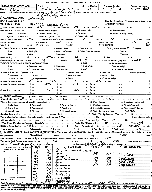
Specific Water Well Detail |
|
|
| Location Info | |||
| Owner: Deeds, John | Status: Constructed | ||
| Location: T5S, R37W, Sec. 21, NW NW NW | County: Cheyenne | ||
| Directions: from Bird City, 10 mi S and 2 mi E | |||
| Latitude: 39.6110479 | Longitude: -101.4864608 | Datum NAD 27 | |
| Latitude: 39.6110455 | Longitude: -101.4869039 | Datum NAD 83 | |
| Longitude and latitude calculated by Survey from township-range-section-quarter calls. Only good to within the quarter call accuracy. | |||
| View well on interactive map | |||
| General Info | ||
| Well Depth: 316 ft. | Elevation: ft. | |
| Static Water Level: 178 ft. | Est. Yield: gpm. | |
| Comp. Date: 13-Aug-1980 | Well Use: Domestic | |
| DWR Applic. #: | Other ID: | |
| Driller Info | ||
| Driller: A.J. Foust Supply Co. Inc. | License #: 144 | |
| Scanned Form | View scan |
|
Chemical Sample Submitted?: No
Water Well disinfected?: | ||
| Ground water encountered: 0 ft. , 0 ft. , 0 ft. | ||
| Pump test data: Well water was 0 ft after 0 hours pumping 0 gpm | ||
| Casing Info | ||
| Casing Type:
Casing Joints: |
Diam: 0 in. to 0 ft
Diam: 0 in. to 0 ft Diam: 0 in. to 0 ft | |
| Casing height above land surface: in
Casing Weight: lbs/ft Wall thickness or gauge no.: | ||
| Screen and Perforation Info | ||
| Screen Type: | Screen Openings: | |
| Screen-perforated intervals | From: 296 ft to 316 ft
From: 0 ft to 0 ft From: 0 ft to 0 ft | |
| Gravel pack intervals | From: ft to ft | |
| Grout Info | ||
| Grout used: | From: 0 to 0 ft
From: 0 to 0 ft From: 0 to 0 ft | |
| Source of Possible Contamination | ||
| Source: | ||
| Direction from well: | Distance: 0 ft | |
| Lithologic Log
(Log data entered by KGS.) | ||
| From: 0 ft. to 177 ft. | Clay, sandstone, gravel | |
| From: 177 ft. to 182 ft. | Sand | |
| From: 182 ft. to 185 ft. | Sandy clay | |
| From: 185 ft. to 188 ft. | Hard sandstone | |
| From: 188 ft. to 193 ft. | Sand | |
| From: 193 ft. to 210 ft. | Sandstone | |
| From: 210 ft. to 215 ft. | Fine sand | |
| From: 215 ft. to 225 ft. | Sandstone | |
| From: 225 ft. to 237 ft. | Sandy clay | |
| From: 237 ft. to 245 ft. | Fine sand | |
| From: 245 ft. to 250 ft. | Sandy clay | |
| From: 250 ft. to 271 ft. | Fine sand | |
| From: 271 ft. to 276 ft. | Sandy clay | |
| From: 276 ft. to 312 ft. | Fine sand | |
| From: 312 ft. to 316 ft. | Soapstone | |