|
|
|
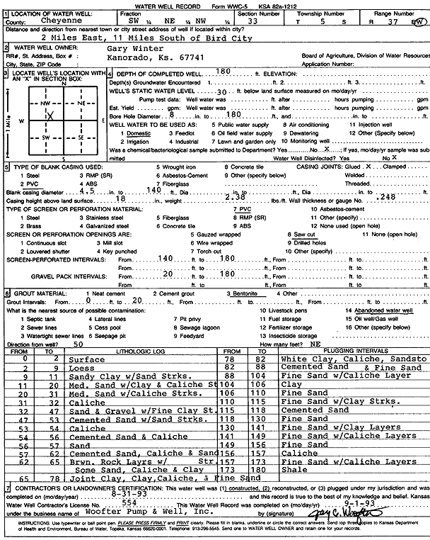
Specific Water Well Detail |
|
|
| Location Info | |||
| Owner: Winter, Gary | Status: Constructed | ||
| Location: T5S, R37W, Sec. 33, SW NE NW | County: Cheyenne | ||
| Directions: from Bird City, 2 mi E and 11 mi S | |||
| Latitude: 39.5801135 | Longitude: -101.4824041 | Datum NAD 27 | |
| Latitude: 39.5801114 | Longitude: -101.4828473 | Datum NAD 83 | |
| Longitude and latitude calculated by Survey from township-range-section-quarter calls. Only good to within the quarter call accuracy. | |||
| View well on interactive map | |||
| General Info | ||
| Well Depth: 180 ft. | Elevation: ft. | |
| Static Water Level: 30 ft. | Est. Yield: gpm. | |
| Comp. Date: 31-Aug-1993 | Well Use: Domestic | |
| DWR Applic. #: | Other ID: | |
| Driller Info | ||
| Driller: Jay C. Woofter Pump & Well, Inc. | License #: 554 | |
| Scanned Form | View scan |
|
Chemical Sample Submitted?: No
Water Well disinfected?: | ||
| Ground water encountered: 0 ft. , 0 ft. , 0 ft. | ||
| Pump test data: Well water was 0 ft after 0 hours pumping 0 gpm | ||
| Casing Info | ||
| Casing Type: PVC
Casing Joints: |
Diam: 4 in. to 140 ft
Diam: 0 in. to 0 ft Diam: 0 in. to 0 ft | |
| Casing height above land surface: in
Casing Weight: lbs/ft Wall thickness or gauge no.: | ||
| Screen and Perforation Info | ||
| Screen Type: PVC | Screen Openings: Saw cut | |
| Screen-perforated intervals | From: 140 ft to 180 ft
From: 0 ft to 0 ft From: 0 ft to 0 ft | |
| Gravel pack intervals | From: ft to ft | |
| Grout Info | ||
| Grout used: Bentonite | From: 0 to 20 ft
From: 0 to 0 ft From: 0 to 0 ft | |
| Source of Possible Contamination | ||
| Source: Abandoned water well | ||
| Direction from well: | Distance: 0 ft | |
| Lithologic Log
(Log data entered by KGS.) | ||
| From: 0 ft. to 2 ft. | Surface | |
| From: 2 ft. to 9 ft. | Loess | |
| From: 9 ft. to 11 ft. | Sandy clay with sand streaks | |
| From: 11 ft. to 20 ft. | Medium sand with clay and caliche streak | |
| From: 20 ft. to 31 ft. | Medium sand with caliche streaks | |
| From: 31 ft. to 32 ft. | Caliche | |
| From: 32 ft. to 47 ft. | Sand and gravel with fine clay streak | |
| From: 47 ft. to 53 ft. | Cemented sand with sand streaks | |
| From: 53 ft. to 54 ft. | Caliche | |
| From: 54 ft. to 56 ft. | Cemented sand and caliche | |
| From: 56 ft. to 57 ft. | Sand | |
| From: 57 ft. to 62 ft. | Cemented sand, caliche and sand streak | |
| From: 62 ft. to 65 ft. | Brown rock layers with some sand, caliche and clay | |
| From: 65 ft. to 78 ft. | Joint clay, clay caliche and fine sand | |
| From: 78 ft. to 82 ft. | White clay, caliche, sandstone | |
| From: 82 ft. to 88 ft. | Cemented sand and fine sand | |
| From: 88 ft. to 104 ft. | Fine sand with caliche layer | |
| From: 104 ft. to 106 ft. | Clay | |
| From: 106 ft. to 110 ft. | Fine sand | |
| From: 110 ft. to 115 ft. | Fine sand with clay streaks | |
| From: 115 ft. to 118 ft. | Cemented sand | |
| From: 118 ft. to 130 ft. | Fine sand | |
| From: 130 ft. to 141 ft. | Fine sand with clay layers | |
| From: 141 ft. to 149 ft. | Fine sand with caliche layers | |
| From: 149 ft. to 156 ft. | Fine sand | |
| From: 156 ft. to 157 ft. | Caliche | |
| From: 157 ft. to 173 ft. | Fine sand with caliche layers | |
| From: 173 ft. to 180 ft. | Shale | |