|
|
|
Specific Water Well Detail |
|
|
| Location Info | |||
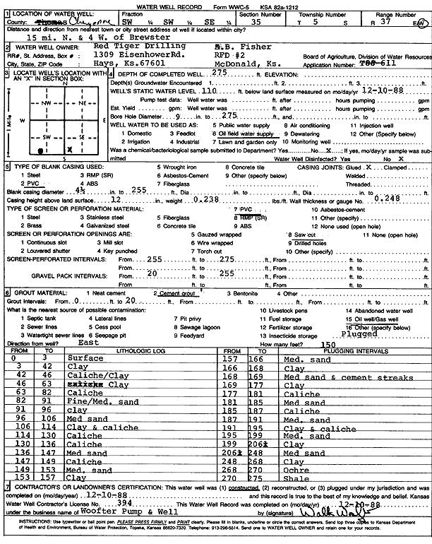
| Owner: Red Tiger Drilling/A.B. Fisher | Status: Constructed | ||
| Location: T5S, R37W, Sec. 35, SW SW SE | County: Cheyenne | ||
| Directions: from Brewster, 15 mi N and 4 mi W | |||
| Latitude: 39.5692315 | Longitude: -101.4404089 | Datum NAD 27 | |
| Latitude: 39.5692299 | Longitude: -101.4408511 | Datum NAD 83 | |
| Longitude and latitude calculated by Survey from township-range-section-quarter calls. Only good to within the quarter call accuracy. | |||
| View well on interactive map | |||
| General Info | ||
| Well Depth: 275 ft. | Elevation: ft. | |
| Static Water Level: 110 ft. | Est. Yield: gpm. | |
| Comp. Date: 10-Dec-1988 | Well Use: Oil Field Water Supply | |
| DWR Applic. #: T88-611 | Other ID: | |
| Links | |
| No Wizard information available. | |
| View info from WIMAS Water Right Data base... | |
| Driller Info | ||
| Driller: Walter Woofter Pump & Well | License #: 394 | |
| Scanned Form | View scan |
|
Chemical Sample Submitted?: No
Water Well disinfected?: | ||
| Ground water encountered: 0 ft. , 0 ft. , 0 ft. | ||
| Pump test data: Well water was 0 ft after 0 hours pumping 0 gpm | ||
| Casing Info | ||
| Casing Type: PVC
Casing Joints: |
Diam: 4 in. to 255 ft
Diam: 0 in. to 0 ft Diam: 0 in. to 0 ft | |
| Casing height above land surface: in
Casing Weight: lbs/ft Wall thickness or gauge no.: | ||
| Screen and Perforation Info | ||
| Screen Type: PVC | Screen Openings: Saw cut | |
| Screen-perforated intervals | From: 255 ft to 275 ft
From: 0 ft to 0 ft From: 0 ft to 0 ft | |
| Gravel pack intervals | From: ft to ft | |
| Grout Info | ||
| Grout used: Cement grout | From: 0 to 20 ft
From: 0 to 0 ft From: 0 to 0 ft | |
| Source of Possible Contamination | ||
| Source: Oil well/gas well | ||
| Direction from well: | Distance: 0 ft | |
| Lithologic Log
(Log data entered by KGS.) | ||
| From: 0 ft. to 3 ft. | Surface | |
| From: 3 ft. to 42 ft. | Clay | |
| From: 42 ft. to 46 ft. | Caliche, clay | |
| From: 46 ft. to 63 ft. | Clay | |
| From: 63 ft. to 82 ft. | Caliche | |
| From: 82 ft. to 91 ft. | Clay | |
| From: 91 ft. to 96 ft. | Clay | |
| From: 96 ft. to 106 ft. | Medium sand | |
| From: 106 ft. to 114 ft. | Clay and caliche | |
| From: 114 ft. to 130 ft. | Caliche | |
| From: 130 ft. to 136 ft. | Caliche | |
| From: 136 ft. to 147 ft. | Medium sand | |
| From: 147 ft. to 149 ft. | Caliche | |
| From: 149 ft. to 153 ft. | Medium sand | |
| From: 153 ft. to 157 ft. | Clay | |
| From: 157 ft. to 166 ft. | Medium sand | |
| From: 166 ft. to 168 ft. | Clay | |
| From: 168 ft. to 169 ft. | Medium sand and cement streaks | |
| From: 169 ft. to 177 ft. | Clay | |
| From: 177 ft. to 181 ft. | Caliche | |
| From: 181 ft. to 185 ft. | Medium sand | |
| From: 185 ft. to 187 ft. | Caliche | |
| From: 187 ft. to 191 ft. | Medium sand | |
| From: 191 ft. to 195 ft. | Clay and caliche | |
| From: 195 ft. to 199 ft. | Medium sand | |
| From: 199 ft. to 206.5 ft. | Clay | |
| From: 206.5 ft. to 248 ft. | Medium sand | |
| From: 248 ft. to 268 ft. | Clay | |
| From: 268 ft. to 270 ft. | Ochre | |
| From: 270 ft. to 275 ft. | Shale | |