|
|
|
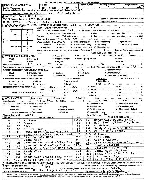
Specific Water Well Detail |
|
|
| Location Info | |||
| Owner: Kricke, Bob | Status: Constructed | ||
| Location: T5S, R38W, Sec. 1, NW NW NW | County: Cheyenne | ||
| Directions: from County Line, 6 mi N and 0.25 mi E | |||
| Latitude: 39.6544882 | Longitude: -101.5419724 | Datum NAD 27 | |
| Latitude: 39.6544847 | Longitude: -101.5424169 | Datum NAD 83 | |
| Longitude and latitude calculated by Survey from township-range-section-quarter calls. Only good to within the quarter call accuracy. | |||
| View well on interactive map | |||
| General Info | ||
| Well Depth: 335 ft. | Elevation: ft. | |
| Static Water Level: 194 ft. | Est. Yield: gpm. | |
| Comp. Date: 31-May-1994 | Well Use: Domestic | |
| DWR Applic. #: | Other ID: | |
| Driller Info | ||
| Driller: Jay C. Woofter Pump & Well, Inc. | License #: 554 | |
| Scanned Form | View scan |
|
Chemical Sample Submitted?: No
Water Well disinfected?: | ||
| Ground water encountered: 0 ft. , 0 ft. , 0 ft. | ||
| Pump test data: Well water was 0 ft after 0 hours pumping 0 gpm | ||
| Casing Info | ||
| Casing Type: PVC
Casing Joints: |
Diam: 4 in. to 295 ft
Diam: 0 in. to 0 ft Diam: 0 in. to 0 ft | |
| Casing height above land surface: in
Casing Weight: lbs/ft Wall thickness or gauge no.: | ||
| Screen and Perforation Info | ||
| Screen Type: PVC | Screen Openings: Saw cut | |
| Screen-perforated intervals | From: 295 ft to 335 ft
From: 0 ft to 0 ft From: 0 ft to 0 ft | |
| Gravel pack intervals | From: ft to ft | |
| Grout Info | ||
| Grout used: Bentonite | From: 0 to 20 ft
From: 0 to 0 ft From: 0 to 0 ft | |
| Source of Possible Contamination | ||
| Source: Abandoned water well | ||
| Direction from well: | Distance: 0 ft | |
| Lithologic Log
(Log data entered by KGS.) | ||
| From: 0 ft. to 2 ft. | Surface | |
| From: 2 ft. to 10 ft. | Loess | |
| From: 10 ft. to 70 ft. | Clay | |
| From: 70 ft. to 80 ft. | Sticky clay | |
| From: 80 ft. to 109 ft. | Sandy clay with caliche streaks | |
| From: 109 ft. to 113 ft. | Sand clay with caliche and fine sand | |
| From: 113 ft. to 116 ft. | Fine to medium sand | |
| From: 116 ft. to 117 ft. | Sandy clay | |
| From: 117 ft. to 125 ft. | Fine to medium sand with clay lens | |
| From: 125 ft. to 130 ft. | Cemented sand with clay and sand streak | |
| From: 130 ft. to 136 ft. | Sandy clay, cemented sand streak | |
| From: 136 ft. to 139 ft. | Sandy clay | |
| From: 139 ft. to 140 ft. | Sand | |
| From: 140 ft. to 152 ft. | Sandy clay with some sand streaks | |
| From: 152 ft. to 156.5 ft. | Fine to medium sand with clay lens | |
| From: 156.5 ft. to 163 ft. | Sandy clay with sand streaks | |
| From: 163 ft. to 185 ft. | Medium sand with fine clay lenses | |
| From: 185 ft. to 191 ft. | Sandstone | |
| From: 191 ft. to 199 ft. | Sandy clay with some sand | |
| From: 199 ft. to 213 ft. | Clay and sand streaks | |
| From: 213 ft. to 215 ft. | Caliche | |
| From: 215 ft. to 219 ft. | Fine sand | |
| From: 219 ft. to 224 ft. | Clay and caliche | |
| From: 224 ft. to 234 ft. | Fine to medium sand, clay lens | |
| From: 234 ft. to 265 ft. | Clay and caliche | |
| From: 265 ft. to 278 ft. | Caliche with some clay | |
| From: 278 ft. to 282 ft. | Sandy clay with caliche | |
| From: 282 ft. to 303 ft. | Sandy clay with sand streaks | |
| From: 303 ft. to 308 ft. | Caliche and clay | |
| From: 308 ft. to 335 ft. | Sand with clay and caliche | |