|
|
|
Specific Water Well Detail |
|
|
| Location Info | |||
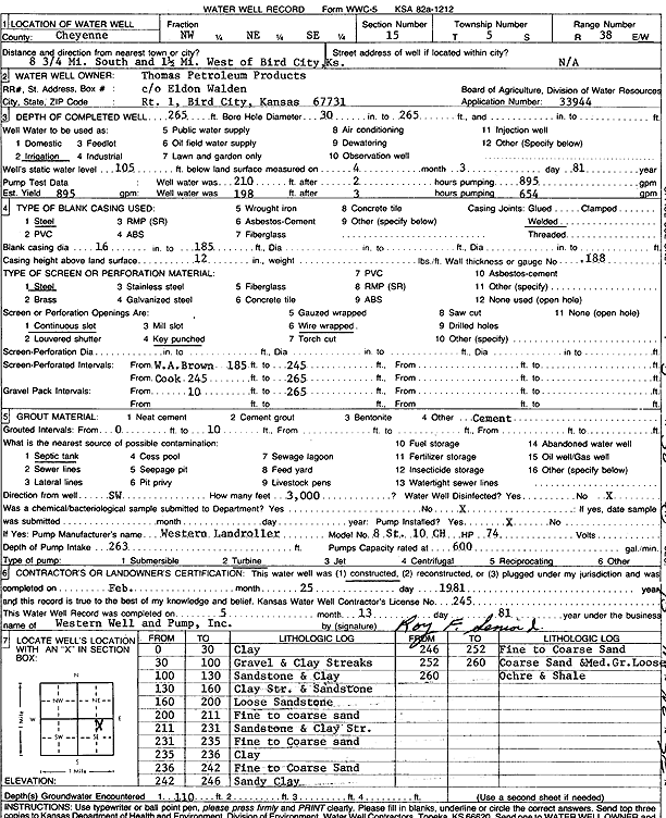
| Owner: Thomas Petroleum Products | Status: Constructed | ||
| Location: T5S, R38W, Sec. 15, NW NE SE | County: Cheyenne | ||
| Directions: from Bird City, 8.75 mi S and 1.5 mi W | |||
| Latitude: 39.6182501 | Longitude: -101.5660316 | Datum NAD 27 | |
| Latitude: 39.6182467 | Longitude: -101.5664771 | Datum NAD 83 | |
| Longitude and latitude calculated by Survey from township-range-section-quarter calls. Only good to within the quarter call accuracy. | |||
| View well on interactive map | |||
| General Info | ||
| Well Depth: 265 ft. | Elevation: ft. | |
| Static Water Level: 105 ft. | Est. Yield: 895 gpm. | |
| Comp. Date: 25-Feb-1981 | Well Use: Irrigation | |
| DWR Applic. #: 33944 | Other ID: | |
| Links | |
| No Wizard information available. | |
| View info from WIMAS Water Right Data base... | |
| Driller Info | ||
| Driller: Western Well & Pump, Inc. | License #: 245 | |
| Scanned Form | View scan |
|
Chemical Sample Submitted?: No
Water Well disinfected?: | ||
| Ground water encountered: 0 ft. , 0 ft. , 0 ft. | ||
| Pump test data: Well water was 0 ft after 0 hours pumping 0 gpm | ||
| Casing Info | ||
| Casing Type:
Casing Joints: |
Diam: 0 in. to 0 ft
Diam: 0 in. to 0 ft Diam: 0 in. to 0 ft | |
| Casing height above land surface: in
Casing Weight: lbs/ft Wall thickness or gauge no.: | ||
| Screen and Perforation Info | ||
| Screen Type: | Screen Openings: | |
| Screen-perforated intervals | From: 185 ft to 265 ft
From: 0 ft to 0 ft From: 0 ft to 0 ft | |
| Gravel pack intervals | From: ft to ft | |
| Grout Info | ||
| Grout used: | From: 0 to 0 ft
From: 0 to 0 ft From: 0 to 0 ft | |
| Source of Possible Contamination | ||
| Source: | ||
| Direction from well: | Distance: 0 ft | |
| Lithologic Log
(Log data entered by KGS.) | ||
| From: 0 ft. to 30 ft. | Clay | |
| From: 30 ft. to 100 ft. | Gravel and clay streaks | |
| From: 100 ft. to 130 ft. | Sandstone and clay | |
| From: 130 ft. to 160 ft. | Clay streak and sandstone | |
| From: 160 ft. to 200 ft. | Loose sandstone | |
| From: 200 ft. to 211 ft. | Fine to coarse sand | |
| From: 211 ft. to 231 ft. | Sandstone and clay streak | |
| From: 231 ft. to 235 ft. | Fine to coarse sand | |
| From: 235 ft. to 236 ft. | Clay | |
| From: 236 ft. to 242 ft. | Fine to coarse sand | |
| From: 242 ft. to 246 ft. | Sandy clay | |
| From: 246 ft. to 252 ft. | Fine to coarse sand | |
| From: 252 ft. to 260 ft. | Coarse sand and medium gravel loose | |
| From: 260 ft. to ft. | Ochre, shale | |