|
|
|
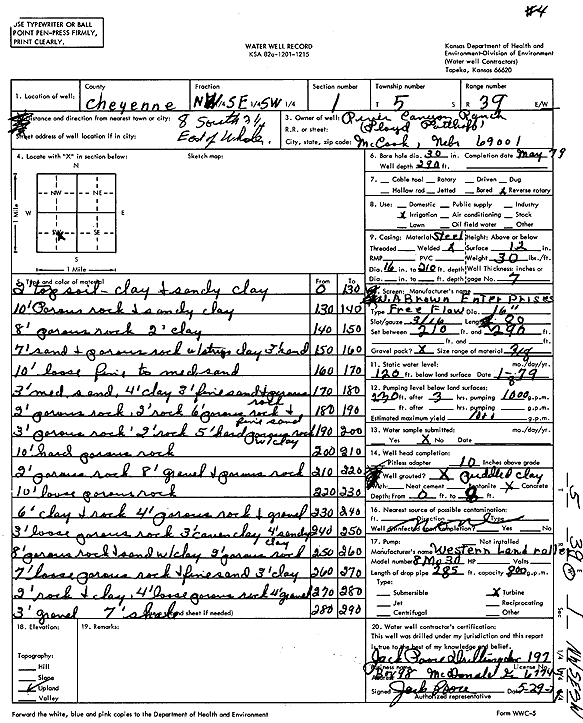
Specific Water Well Detail |
|
|
| Location Info | |||
| Owner: River Canyon Ranch | Status: Constructed | ||
| Location: T5S, R39W, Sec. 1, NW SE SW | County: Cheyenne | ||
| Directions: from Wheeler, 8 mi S and 3.25 mi E | |||
| Latitude: 39.6435033 | Longitude: -101.6500521 | Datum NAD 27 | |
| Latitude: 39.6434987 | Longitude: -101.6505 | Datum NAD 83 | |
| Longitude and latitude calculated by Survey from township-range-section-quarter calls. Only good to within the quarter call accuracy. | |||
| View well on interactive map | |||
| General Info | ||
| Well Depth: 290 ft. | Elevation: ft. | |
| Static Water Level: 120 ft. | Est. Yield: 1000 gpm. | |
| Comp. Date: 01-May-1979 | Well Use: Irrigation | |
| DWR Applic. #: | Other ID: Well 4 | |
| Links | |
| No Wizard information available. | |
| View info from WIMAS Water Right Data base... | |
| Driller Info | ||
| Driller: Jack Poore Drilling Inc. | License #: 197 | |
| Scanned Form | View scan |
|
Chemical Sample Submitted?: No
Water Well disinfected?: | ||
| Ground water encountered: 0 ft. , 0 ft. , 0 ft. | ||
| Pump test data: Well water was 0 ft after 0 hours pumping 0 gpm | ||
| Casing Info | ||
| Casing Type:
Casing Joints: |
Diam: 0 in. to 0 ft
Diam: 0 in. to 0 ft Diam: 0 in. to 0 ft | |
| Casing height above land surface: in
Casing Weight: lbs/ft Wall thickness or gauge no.: | ||
| Screen and Perforation Info | ||
| Screen Type: | Screen Openings: | |
| Screen-perforated intervals | From: 210 ft to 290 ft
From: 0 ft to 0 ft From: 0 ft to 0 ft | |
| Gravel pack intervals | From: ft to ft | |
| Grout Info | ||
| Grout used: | From: 0 to 0 ft
From: 0 to 0 ft From: 0 to 0 ft | |
| Source of Possible Contamination | ||
| Source: | ||
| Direction from well: | Distance: 0 ft | |
| Lithologic Log
(Log data entered by KGS.) | ||
| From: 0 ft. to 130 ft. | Top soil, clay and sandy clay | |
| From: 130 ft. to 140 ft. | Rock and clay | |
| From: 140 ft. to 148 ft. | Rock | |
| From: 148 ft. to 150 ft. | Clay | |
| From: 150 ft. to 157 ft. | Sand and rock with layers of clay | |
| From: 157 ft. to 160 ft. | Sand | |
| From: 160 ft. to 170 ft. | Loose fine to medium sand | |
| From: 170 ft. to 173 ft. | Medium sand | |
| From: 173 ft. to 177 ft. | Clay | |
| From: 177 ft. to 180 ft. | Find sand and rock | |
| From: 180 ft. to 182 ft. | Rock | |
| From: 182 ft. to 184 ft. | Rock | |
| From: 184 ft. to 190 ft. | Rock and fine sand | |
| From: 190 ft. to 193 ft. | Rock | |
| From: 193 ft. to 195 ft. | Rock | |
| From: 195 ft. to 200 ft. | Rock with clay | |
| From: 200 ft. to 210 ft. | Rock | |
| From: 210 ft. to 212 ft. | Rock | |
| From: 212 ft. to 220 ft. | Gravel and rock | |
| From: 220 ft. to 230 ft. | Loose rock | |
| From: 230 ft. to 236 ft. | Clay and rock | |
| From: 236 ft. to 240 ft. | Rock and gravel | |
| From: 240 ft. to 243 ft. | Loose rock | |
| From: 243 ft. to 246 ft. | Clay | |
| From: 246 ft. to 250 ft. | Clay | |
| From: 250 ft. to 258 ft. | Rock and sand with clay | |
| From: 258 ft. to 260 ft. | Rock | |
| From: 260 ft. to 267 ft. | Loose rock and fine sand | |
| From: 267 ft. to 270 ft. | Clay | |
| From: 270 ft. to 272 ft. | Rock and clay | |
| From: 272 ft. to 276 ft. | Loose rock | |
| From: 276 ft. to 280 ft. | Gravel | |
| From: 280 ft. to 283 ft. | Gravel | |
| From: 283 ft. to 290 ft. | Shale | |