|
|
|
Specific Water Well Detail |
|
|
| Location Info | |||
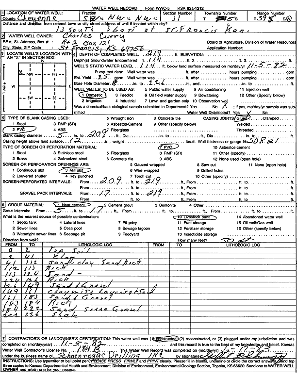
| Owner: Curry, Charles | Status: Constructed | ||
| Location: T5S, R39W, Sec. 31, SW NW NW | County: Cheyenne | ||
| Directions: from St. Francis, 13 mi S and 3 mi E | |||
| Latitude: 39.580317 | Longitude: -101.7493445 | Datum NAD 27 | |
| Latitude: 39.5803122 | Longitude: -101.7497956 | Datum NAD 83 | |
| Longitude and latitude calculated by Survey from township-range-section-quarter calls. Only good to within the quarter call accuracy. | |||
| View well on interactive map | |||
| General Info | ||
| Well Depth: 219 ft. | Elevation: ft. | |
| Static Water Level: 114 ft. | Est. Yield: 25 gpm. | |
| Comp. Date: 05-Nov-1982 | Well Use: Domestic | |
| DWR Applic. #: | Other ID: | |
| Driller Info | ||
| Driller: Schoenrogge Drilling, Inc. | License #: 184 | |
| Scanned Form | View scan |
|
Chemical Sample Submitted?: No
Water Well disinfected?: | ||
| Ground water encountered: 0 ft. , 0 ft. , 0 ft. | ||
| Pump test data: Well water was 0 ft after 0 hours pumping 0 gpm | ||
| Casing Info | ||
| Casing Type:
Casing Joints: |
Diam: 0 in. to 0 ft
Diam: 0 in. to 0 ft Diam: 0 in. to 0 ft | |
| Casing height above land surface: in
Casing Weight: lbs/ft Wall thickness or gauge no.: | ||
| Screen and Perforation Info | ||
| Screen Type: | Screen Openings: | |
| Screen-perforated intervals | From: 209 ft to 219 ft
From: 0 ft to 0 ft From: 0 ft to 0 ft | |
| Gravel pack intervals | From: ft to ft | |
| Grout Info | ||
| Grout used: | From: 0 to 0 ft
From: 0 to 0 ft From: 0 to 0 ft | |
| Source of Possible Contamination | ||
| Source: | ||
| Direction from well: | Distance: 0 ft | |
| Lithologic Log
(Log data entered by KGS.) | ||
| From: 0 ft. to 2 ft. | Top soil | |
| From: 2 ft. to 41 ft. | Clay | |
| From: 41 ft. to 112 ft. | Sand, clay, sand rock | |
| From: 112 ft. to 113 ft. | Rock | |
| From: 113 ft. to 124 ft. | Sand | |
| From: 124 ft. to 126 ft. | Rock | |
| From: 126 ft. to 149 ft. | Sand and gravel | |
| From: 149 ft. to 161 ft. | Clay with layers of sand | |
| From: 161 ft. to 183 ft. | Sand and gravel | |
| From: 183 ft. to 184 ft. | Rock | |
| From: 184 ft. to 222 ft. | Sand and gravel | |
| From: 222 ft. to 228 ft. | Shale | |