|
|
|
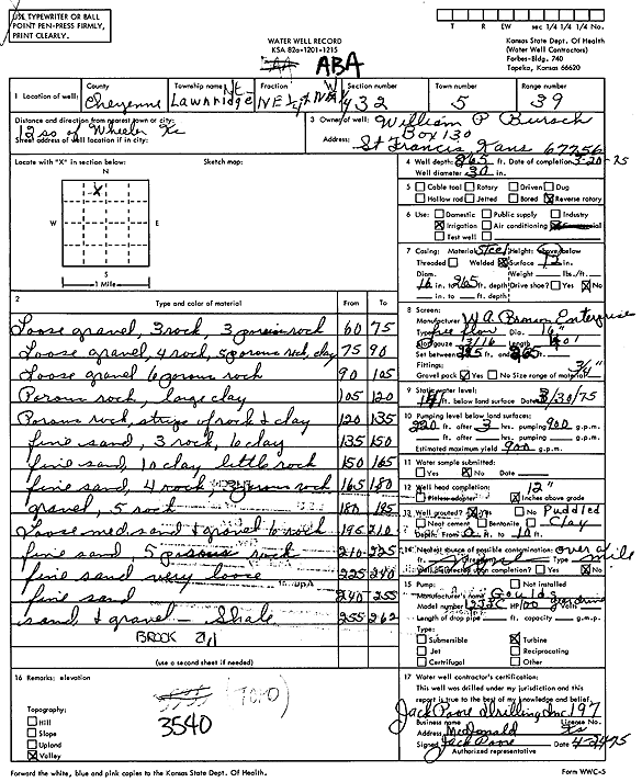
Specific Water Well Detail |
|
|
| Location Info | |||
| Owner: Bursch, William | Status: Constructed | ||
| Location: T5S, R39W, Sec. 32, C NE NW | County: Cheyenne | ||
| Directions: from Wheeler, 12 mi S | |||
| Latitude: 39.5810519 | Longitude: -101.7246391 | Datum NAD 27 | |
| Latitude: 39.5810474 | Longitude: -101.7250895 | Datum NAD 83 | |
| Longitude and latitude calculated by Survey from township-range-section-quarter calls. Only good to within the quarter call accuracy. | |||
| View well on interactive map | |||
| General Info | ||
| Well Depth: 265 ft. | Elevation: ft. | |
| Static Water Level: 141 ft. | Est. Yield: 900 gpm. | |
| Comp. Date: 20-Mar-1975 | Well Use: Irrigation | |
| DWR Applic. #: | Other ID: | |
| Links | |
| View info from Wizard Water Level Data base... | |
| View info from WIMAS Water Right Data base... | |
| Driller Info | ||
| Driller: Jack Poore Drilling Inc. | License #: 197 | |
| Scanned Form | View scan |
|
Chemical Sample Submitted?: No
Water Well disinfected?: | ||
| Ground water encountered: 0 ft. , 0 ft. , 0 ft. | ||
| Pump test data: Well water was 0 ft after 0 hours pumping 0 gpm | ||
| Casing Info | ||
| Casing Type:
Casing Joints: |
Diam: 0 in. to 0 ft
Diam: 0 in. to 0 ft Diam: 0 in. to 0 ft | |
| Casing height above land surface: in
Casing Weight: lbs/ft Wall thickness or gauge no.: | ||
| Screen and Perforation Info | ||
| Screen Type: | Screen Openings: | |
| Screen-perforated intervals | From: 225 ft to 265 ft
From: 0 ft to 0 ft From: 0 ft to 0 ft | |
| Gravel pack intervals | From: ft to ft | |
| Grout Info | ||
| Grout used: | From: 0 to 0 ft
From: 0 to 0 ft From: 0 to 0 ft | |
| Source of Possible Contamination | ||
| Source: | ||
| Direction from well: | Distance: 0 ft | |
| Lithologic Log
(Log data entered by KGS.) | ||
| From: 60 ft. to 75 ft. | Loose gravel, rock | |
| From: 75 ft. to 90 ft. | Loose gravel, rock, clay | |
| From: 90 ft. to 105 ft. | Loose gravel, rock | |
| From: 105 ft. to 120 ft. | Rock, clay | |
| From: 120 ft. to 135 ft. | Rock and clay | |
| From: 135 ft. to 150 ft. | Fine sand, rock, clay | |
| From: 150 ft. to 165 ft. | Fine sand. clay, rock | |
| From: 165 ft. to 180 ft. | Fine sand and rock | |
| From: 180 ft. to 195 ft. | Gravel and rock | |
| From: 195 ft. to 210 ft. | Loose medium sand and gravel | |
| From: 210 ft. to 225 ft. | Fine sand, rock | |
| From: 225 ft. to 240 ft. | Fine sand very loose | |
| From: 240 ft. to 255 ft. | Fine sand | |
| From: 255 ft. to 262 ft. | Sand and gravel, shale | |