|
|
|
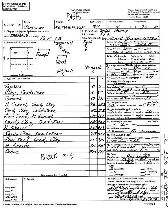
Specific Water Well Detail |
|
|
| Location Info | |||
| Owner: Murry, Ralph | Status: Constructed | ||
| Location: T5S, R39W, Sec. 34, NW NW NW | County: Cheyenne | ||
| Directions: from Goodland, 16 mi N and 1 mi E | |||
| Latitude: 39.581882 | Longitude: -101.693058 | Datum NAD 27 | |
| Latitude: 39.5818777 | Longitude: -101.6935074 | Datum NAD 83 | |
| Longitude and latitude calculated by Survey from township-range-section-quarter calls. Only good to within the quarter call accuracy. | |||
| View well on interactive map | |||
| General Info | ||
| Well Depth: 319 ft. | Elevation: ft. | |
| Static Water Level: 145 ft. | Est. Yield: 50 gpm. | |
| Comp. Date: 14-May-1979 | Well Use: Domestic | |
| DWR Applic. #: | Other ID: | |
| Driller Info | ||
| Driller: S & H Drilling Co., Inc. | License #: 166 | |
| Scanned Form | View scan |
|
Chemical Sample Submitted?: No
Water Well disinfected?: | ||
| Ground water encountered: 0 ft. , 0 ft. , 0 ft. | ||
| Pump test data: Well water was 0 ft after 0 hours pumping 0 gpm | ||
| Casing Info | ||
| Casing Type:
Casing Joints: |
Diam: 0 in. to 0 ft
Diam: 0 in. to 0 ft Diam: 0 in. to 0 ft | |
| Casing height above land surface: in
Casing Weight: lbs/ft Wall thickness or gauge no.: | ||
| Screen and Perforation Info | ||
| Screen Type: | Screen Openings: | |
| Screen-perforated intervals | From: 287 ft to 319 ft
From: 0 ft to 0 ft From: 0 ft to 0 ft | |
| Gravel pack intervals | From: ft to ft | |
| Grout Info | ||
| Grout used: | From: 0 to 0 ft
From: 0 to 0 ft From: 0 to 0 ft | |
| Source of Possible Contamination | ||
| Source: | ||
| Direction from well: | Distance: 0 ft | |
| Lithologic Log
(Log data entered by KGS.) | ||
| From: 0 ft. to 3 ft. | Top soil | |
| From: 3 ft. to 87 ft. | Clay, sandstone | |
| From: 87 ft. to 92 ft. | Gravel | |
| From: 92 ft. to 152 ft. | Medium gravel, sandy clay | |
| From: 152 ft. to 178 ft. | Sandy clay, sandstone | |
| From: 178 ft. to 186 ft. | Fine sand, medium gravel | |
| From: 186 ft. to 207 ft. | Sandy clay, sandstone | |
| From: 207 ft. to 213 ft. | Medium gravel | |
| From: 213 ft. to 257 ft. | Sandy clay, sandstone | |
| From: 257 ft. to 310 ft. | Fine sand, sandy clay | |
| From: 310 ft. to 315 ft. | Medium gravel | |
| From: 315 ft. to 319 ft. | Ochre | |