|
|
|
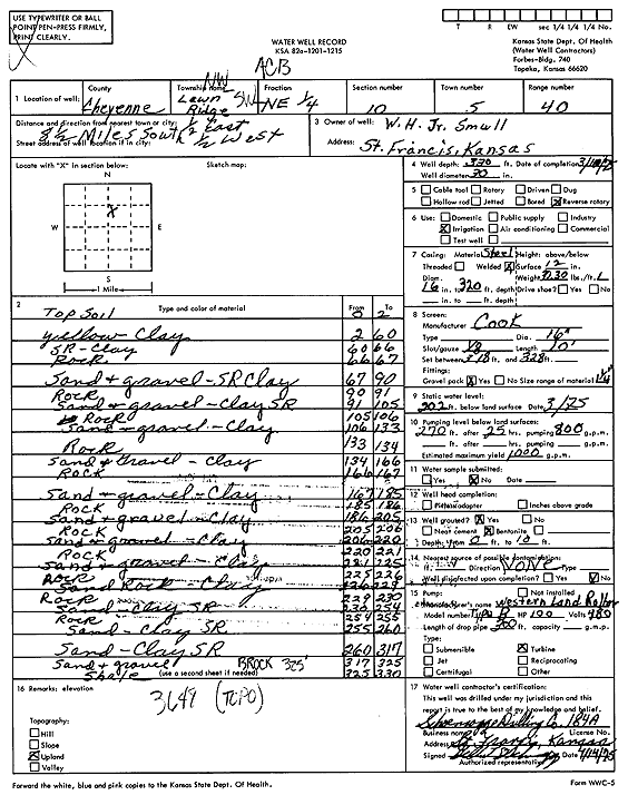
Specific Water Well Detail |
|
|
| Location Info | |||
| Owner: Small, W.H., Jr. | Status: Constructed | ||
| Location: T5S, R40W, Sec. 10, NW SW NE | County: Cheyenne | ||
| Directions: from St. Francis, 8.5 mi S, 0.5 mi E, and 0.5 mi W | |||
| Latitude: 39.6363938 | Longitude: -101.7956895 | Datum NAD 27 | |
| Latitude: 39.6363881 | Longitude: -101.7961422 | Datum NAD 83 | |
| Longitude and latitude calculated by Survey from township-range-section-quarter calls. Only good to within the quarter call accuracy. | |||
| View well on interactive map | |||
| General Info | ||
| Well Depth: 330 ft. | Elevation: ft. | |
| Static Water Level: 202 ft. | Est. Yield: 1000 gpm. | |
| Comp. Date: 10-Mar-1975 | Well Use: Irrigation | |
| DWR Applic. #: | Other ID: | |
| Links | |
| View info from Wizard Water Level Data base... | |
| View info from WIMAS Water Right Data base... | |
| Driller Info | ||
| Driller: Schoenrogge Drilling, Inc. | License #: 184 | |
| Scanned Form | View scan |
|
Chemical Sample Submitted?: No
Water Well disinfected?: | ||
| Ground water encountered: 0 ft. , 0 ft. , 0 ft. | ||
| Pump test data: Well water was 0 ft after 0 hours pumping 0 gpm | ||
| Casing Info | ||
| Casing Type:
Casing Joints: |
Diam: 0 in. to 0 ft
Diam: 0 in. to 0 ft Diam: 0 in. to 0 ft | |
| Casing height above land surface: in
Casing Weight: lbs/ft Wall thickness or gauge no.: | ||
| Screen and Perforation Info | ||
| Screen Type: | Screen Openings: | |
| Screen-perforated intervals | From: 318 ft to 328 ft
From: 0 ft to 0 ft From: 0 ft to 0 ft | |
| Gravel pack intervals | From: ft to ft | |
| Grout Info | ||
| Grout used: | From: 0 to 0 ft
From: 0 to 0 ft From: 0 to 0 ft | |
| Source of Possible Contamination | ||
| Source: | ||
| Direction from well: | Distance: 0 ft | |
| Lithologic Log
(Log data entered by KGS.) | ||
| From: 0 ft. to 2 ft. | Top soil | |
| From: 2 ft. to 60 ft. | Yellow clay | |
| From: 60 ft. to 66 ft. | Sand rock, clay | |
| From: 66 ft. to 67 ft. | Rock | |
| From: 67 ft. to 90 ft. | Sand and gravel, sand rock clay | |
| From: 90 ft. to 91 ft. | Rock | |
| From: 91 ft. to 105 ft. | Sand and gravel, clay sand rock | |
| From: 105 ft. to 106 ft. | Rock | |
| From: 106 ft. to 133 ft. | Sand, gravel, clay | |
| From: 133 ft. to 134 ft. | Rock | |
| From: 134 ft. to 166 ft. | Sand and gravel, clay | |
| From: 166 ft. to 167 ft. | Rock | |
| From: 167 ft. to 185 ft. | Sand and gravel, clay | |
| From: 185 ft. to 186 ft. | Rock | |
| From: 186 ft. to 205 ft. | Sand and gravel, clay | |
| From: 205 ft. to 206 ft. | Rock | |
| From: 206 ft. to 220 ft. | Sand and gravel, clay | |
| From: 220 ft. to 221 ft. | Rock | |
| From: 221 ft. to 225 ft. | Sand and gravel, clay | |
| From: 225 ft. to 226 ft. | Rock | |
| From: 226 ft. to 229 ft. | Sand rock, clay | |
| From: 229 ft. to 230 ft. | Rock | |
| From: 230 ft. to 254 ft. | Sand, clay sand rock | |
| From: 254 ft. to 255 ft. | Rock | |
| From: 255 ft. to 260 ft. | Sand, clay sand rock | |
| From: 260 ft. to 317 ft. | Sand, clay sand rock | |
| From: 317 ft. to 325 ft. | Sand and gravel | |
| From: 325 ft. to 330 ft. | Shale | |