|
|
|
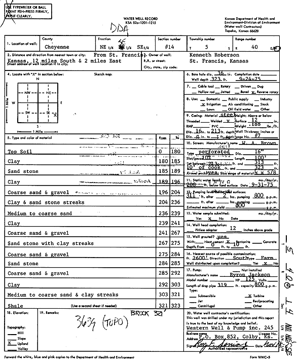
Specific Water Well Detail |
|
|
| Location Info | |||
| Owner: Roberson, Kenneth | Status: Constructed | ||
| Location: T5S, R40W, Sec. 14, NE SE SE | County: Cheyenne | ||
| Directions: from St. Francis, 12 mi S and 2 mi E | |||
| Latitude: 39.6145956 | Longitude: -101.7701504 | Datum NAD 27 | |
| Latitude: 39.6145903 | Longitude: -101.7706022 | Datum NAD 83 | |
| Longitude and latitude calculated by Survey from township-range-section-quarter calls. Only good to within the quarter call accuracy. | |||
| View well on interactive map | |||
| General Info | ||
| Well Depth: 323 ft. | Elevation: ft. | |
| Static Water Level: 200 ft. | Est. Yield: 800 gpm. | |
| Comp. Date: 24-Sep-1975 | Well Use: Irrigation | |
| DWR Applic. #: | Other ID: | |
| Links | |
| View info from Wizard Water Level Data base... | |
| View info from WIMAS Water Right Data base... | |
| Driller Info | ||
| Driller: Western Well & Pump, Inc. | License #: 245 | |
| Scanned Form | View scan |
|
Chemical Sample Submitted?: No
Water Well disinfected?: | ||
| Ground water encountered: 0 ft. , 0 ft. , 0 ft. | ||
| Pump test data: Well water was 0 ft after 0 hours pumping 0 gpm | ||
| Casing Info | ||
| Casing Type:
Casing Joints: |
Diam: 0 in. to 0 ft
Diam: 0 in. to 0 ft Diam: 0 in. to 0 ft | |
| Casing height above land surface: in
Casing Weight: lbs/ft Wall thickness or gauge no.: | ||
| Screen and Perforation Info | ||
| Screen Type: | Screen Openings: | |
| Screen-perforated intervals | From: 213 ft to 313 ft
From: 0 ft to 0 ft From: 0 ft to 0 ft | |
| Gravel pack intervals | From: ft to ft | |
| Grout Info | ||
| Grout used: | From: 0 to 0 ft
From: 0 to 0 ft From: 0 to 0 ft | |
| Source of Possible Contamination | ||
| Source: | ||
| Direction from well: | Distance: 0 ft | |
| Lithologic Log
(Log data entered by KGS.) | ||
| From: 0 ft. to 180 ft. | Top soil | |
| From: 180 ft. to 185 ft. | Clay | |
| From: 185 ft. to 189 ft. | Sandstone | |
| From: 189 ft. to 196 ft. | Clay | |
| From: 196 ft. to 204 ft. | Coarse sand and gravel | |
| From: 204 ft. to 236 ft. | Clay and sandstone streaks | |
| From: 236 ft. to 239 ft. | Medium to coarse sand | |
| From: 239 ft. to 241 ft. | Clay | |
| From: 241 ft. to 267 ft. | Coarse sand and gravel | |
| From: 267 ft. to 275 ft. | Sandstone with clay streaks | |
| From: 275 ft. to 284 ft. | Coarse sand and gravel | |
| From: 284 ft. to 285 ft. | Sandstone | |
| From: 285 ft. to 292 ft. | Coarse sand and gravel | |
| From: 292 ft. to 303 ft. | Clay | |
| From: 303 ft. to 321 ft. | Medium to coarse sand and clay streaks | |
| From: 321 ft. to 323 ft. | Shale | |