|
|
|
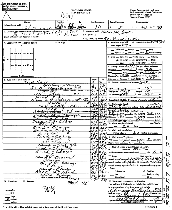
Specific Water Well Detail |
|
|
| Location Info | |||
| Owner: Roberson Brothers | Status: Constructed | ||
| Location: T5S, R40W, Sec. 14, SE SE NE | County: Cheyenne | ||
| Directions: from St. Francis, 10 mi S, 1 mi E, and 0.5 mi S | |||
| Latitude: 39.6200271 | Longitude: -101.7700945 | Datum NAD 27 | |
| Latitude: 39.6200217 | Longitude: -101.7705463 | Datum NAD 83 | |
| Longitude and latitude calculated by Survey from township-range-section-quarter calls. Only good to within the quarter call accuracy. | |||
| View well on interactive map | |||
| General Info | ||
| Well Depth: 334 ft. | Elevation: ft. | |
| Static Water Level: 214 ft. | Est. Yield: 800 gpm. | |
| Comp. Date: 22-May-1976 | Well Use: Irrigation | |
| DWR Applic. #: | Other ID: | |
| Links | |
| View info from Wizard Water Level Data base... | |
| View info from WIMAS Water Right Data base... | |
| Driller Info | ||
| Driller: Schoenrogge Drilling, Inc. | License #: 184 | |
| Scanned Form | View scan |
|
Chemical Sample Submitted?: No
Water Well disinfected?: | ||
| Ground water encountered: 0 ft. , 0 ft. , 0 ft. | ||
| Pump test data: Well water was 0 ft after 0 hours pumping 0 gpm | ||
| Casing Info | ||
| Casing Type:
Casing Joints: |
Diam: 0 in. to 0 ft
Diam: 0 in. to 0 ft Diam: 0 in. to 0 ft | |
| Casing height above land surface: in
Casing Weight: lbs/ft Wall thickness or gauge no.: | ||
| Screen and Perforation Info | ||
| Screen Type: | Screen Openings: | |
| Screen-perforated intervals | From: 324 ft to 334 ft
From: 0 ft to 0 ft From: 0 ft to 0 ft | |
| Gravel pack intervals | From: ft to ft | |
| Grout Info | ||
| Grout used: | From: 0 to 0 ft
From: 0 to 0 ft From: 0 to 0 ft | |
| Source of Possible Contamination | ||
| Source: | ||
| Direction from well: | Distance: 0 ft | |
| Lithologic Log
(Log data entered by KGS.) | ||
| From: 0 ft. to 2 ft. | Top soil | |
| From: 2 ft. to 72 ft. | Yellow clay | |
| From: 72 ft. to 114 ft. | Sand and gravel, clay with layers sand rock | |
| From: 114 ft. to 116 ft. | Rock | |
| From: 116 ft. to 119 ft. | Sand rock, clay | |
| From: 119 ft. to 121 ft. | Hard sand rock | |
| From: 121 ft. to 134 ft. | Sand and gravel with layers sand rock, clay | |
| From: 134 ft. to 135 ft. | Rock | |
| From: 135 ft. to 165 ft. | Sand and gravel, clay, sand rock | |
| From: 165 ft. to 166 ft. | Rock | |
| From: 166 ft. to 195 ft. | Sand and gravel, clay, sand rock | |
| From: 195 ft. to 205 ft. | Sand, sandstone, clay | |
| From: 205 ft. to 215 ft. | Sand and gravel, clay | |
| From: 215 ft. to 221 ft. | Sand, sandstone, clay | |
| From: 221 ft. to 222 ft. | Rock | |
| From: 222 ft. to 230 ft. | Sand, clay | |
| From: 230 ft. to 234 ft. | Sand, clay | |
| From: 234 ft. to 238 ft. | Clay | |
| From: 238 ft. to 242 ft. | Sand, clay | |
| From: 242 ft. to 245 ft. | Rock | |
| From: 245 ft. to 248 ft. | Sand rock, clay | |
| From: 248 ft. to 255 ft. | Sand, clay sand rock | |
| From: 255 ft. to 266 ft. | Sand, clay sand rock | |
| From: 266 ft. to 270 ft. | Sand, clay | |
| From: 270 ft. to 271 ft. | Sand rock | |
| From: 271 ft. to 282 ft. | Sand and gravel | |
| From: 283 ft. to 287 ft. | Clay | |
| From: 287 ft. to 295 ft. | Sand and clay | |
| From: 295 ft. to 309 ft. | Clay | |
| From: 309 ft. to 321 ft. | Sand and clay | |
| From: 321 ft. to 322 ft. | Rock not hard | |
| From: 322 ft. to 330 ft. | Sand, clay | |
| From: 330 ft. to 334 ft. | Shale | |