|
|
|
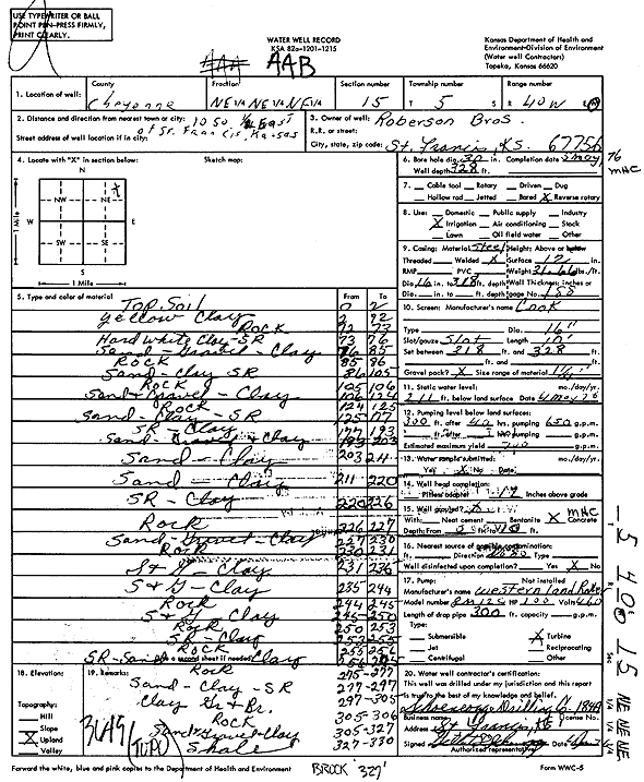
Specific Water Well Detail |
|
|
| Location Info | |||
| Owner: Roberson Brothers | Status: Constructed | ||
| Location: T5S, R40W, Sec. 15, NE NE NE | County: Cheyenne | ||
| Directions: from St. Francis, 10 mi S and 0.5 mi E | |||
| Latitude: 39.625541 | Longitude: -101.7887424 | Datum NAD 27 | |
| Latitude: 39.6255356 | Longitude: -101.7891948 | Datum NAD 83 | |
| Longitude and latitude calculated by Survey from township-range-section-quarter calls. Only good to within the quarter call accuracy. | |||
| View well on interactive map | |||
| General Info | ||
| Well Depth: 328 ft. | Elevation: ft. | |
| Static Water Level: 211 ft. | Est. Yield: 700 gpm. | |
| Comp. Date: 05-May-1976 | Well Use: Irrigation | |
| DWR Applic. #: | Other ID: | |
| Links | |
| View info from Wizard Water Level Data base... | |
| View info from WIMAS Water Right Data base... | |
| Driller Info | ||
| Driller: Schoenrogge Drilling, Inc. | License #: 184 | |
| Scanned Form | View scan |
|
Chemical Sample Submitted?: No
Water Well disinfected?: | ||
| Ground water encountered: 0 ft. , 0 ft. , 0 ft. | ||
| Pump test data: Well water was 0 ft after 0 hours pumping 0 gpm | ||
| Casing Info | ||
| Casing Type:
Casing Joints: |
Diam: 0 in. to 0 ft
Diam: 0 in. to 0 ft Diam: 0 in. to 0 ft | |
| Casing height above land surface: in
Casing Weight: lbs/ft Wall thickness or gauge no.: | ||
| Screen and Perforation Info | ||
| Screen Type: | Screen Openings: | |
| Screen-perforated intervals | From: 318 ft to 328 ft
From: 0 ft to 0 ft From: 0 ft to 0 ft | |
| Gravel pack intervals | From: ft to ft | |
| Grout Info | ||
| Grout used: | From: 0 to 0 ft
From: 0 to 0 ft From: 0 to 0 ft | |
| Source of Possible Contamination | ||
| Source: | ||
| Direction from well: | Distance: 0 ft | |
| Lithologic Log
(Log data entered by KGS.) | ||
| From: 0 ft. to 2 ft. | Top soil | |
| From: 2 ft. to 72 ft. | Yellow clay | |
| From: 72 ft. to 73 ft. | Rock | |
| From: 73 ft. to 76 ft. | Hard white clay, sand rock | |
| From: 76 ft. to 85 ft. | Sand, gravel, clay | |
| From: 85 ft. to 86 ft. | Rock | |
| From: 86 ft. to 105 ft. | Sand, clay sand rock | |
| From: 105 ft. to 106 ft. | Rock | |
| From: 106 ft. to 124 ft. | Sand and gravel, clay | |
| From: 124 ft. to 125 ft. | Rock | |
| From: 125 ft. to 177 ft. | Sand, clay, sand rock | |
| From: 177 ft. to 193 ft. | Sand rock, clay | |
| From: 193 ft. to 203 ft. | Sand, gravel and clay | |
| From: 203 ft. to 211 ft. | Sand, clay | |
| From: 211 ft. to 220 ft. | Sand, clay | |
| From: 220 ft. to 226 ft. | Sand rock, clay | |
| From: 226 ft. to 227 ft. | Rock | |
| From: 227 ft. to 230 ft. | Sand, gravel, clay | |
| From: 230 ft. to 231 ft. | Rock | |
| From: 231 ft. to 235 ft. | Sand and gravel, clay | |
| From: 235 ft. to 244 ft. | Sand and gravel, clay | |
| From: 244 ft. to 245 ft. | Rock | |
| From: 245 ft. to 250 ft. | Sand and gravel, clay | |
| From: 250 ft. to 253 ft. | Rock | |
| From: 253 ft. to 255 ft. | Sand rock, clay | |
| From: 255 ft. to 256 ft. | Rock | |
| From: 256 ft. to 275 ft. | Sand rock, sand, clay | |
| From: 275 ft. to 277 ft. | Rock | |
| From: 277 ft. to 297 ft. | Sand, clay, sand rock | |
| From: 297 ft. to 305 ft. | Clay gravel and rock | |
| From: 305 ft. to 306 ft. | Rock | |
| From: 306 ft. to 327 ft. | Sand and gravel and clay | |
| From: 327 ft. to 330 ft. | Shale | |