|
|
|
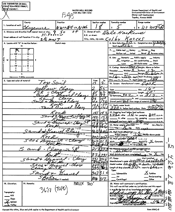
Specific Water Well Detail |
|
|
| Location Info | |||
| Owner: Harkins, Dale | Status: Constructed | ||
| Location: T5S, R40W, Sec. 18, NW NE NW | County: Cheyenne | ||
| Directions: from St. Francis, 9 mi S and 2.5 mi W | |||
| Latitude: 39.6255669 | Longitude: -101.8565946 | Datum NAD 27 | |
| Latitude: 39.6255613 | Longitude: -101.8570496 | Datum NAD 83 | |
| Longitude and latitude calculated by Survey from township-range-section-quarter calls. Only good to within the quarter call accuracy. | |||
| View well on interactive map | |||
| General Info | ||
| Well Depth: 312 ft. | Elevation: ft. | |
| Static Water Level: 220 ft. | Est. Yield: 900 gpm. | |
| Comp. Date: 28-Sep-1976 | Well Use: Irrigation | |
| DWR Applic. #: | Other ID: | |
| Links | |
| View info from Wizard Water Level Data base... | |
| View info from WIMAS Water Right Data base... | |
| Driller Info | ||
| Driller: Schoenrogge Drilling, Inc. | License #: 184 | |
| Scanned Form | View scan |
|
Chemical Sample Submitted?: No
Water Well disinfected?: | ||
| Ground water encountered: 0 ft. , 0 ft. , 0 ft. | ||
| Pump test data: Well water was 0 ft after 0 hours pumping 0 gpm | ||
| Casing Info | ||
| Casing Type:
Casing Joints: |
Diam: 0 in. to 0 ft
Diam: 0 in. to 0 ft Diam: 0 in. to 0 ft | |
| Casing height above land surface: in
Casing Weight: lbs/ft Wall thickness or gauge no.: | ||
| Screen and Perforation Info | ||
| Screen Type: | Screen Openings: | |
| Screen-perforated intervals | From: 302 ft to 312 ft
From: 0 ft to 0 ft From: 0 ft to 0 ft | |
| Gravel pack intervals | From: ft to ft | |
| Grout Info | ||
| Grout used: | From: 0 to 0 ft
From: 0 to 0 ft From: 0 to 0 ft | |
| Source of Possible Contamination | ||
| Source: | ||
| Direction from well: | Distance: 0 ft | |
| Lithologic Log
(Log data entered by KGS.) | ||
| From: 0 ft. to 2 ft. | Top soil | |
| From: 2 ft. to 55 ft. | Yellow Clay | |
| From: 55 ft. to 62 ft. | Sand rock, clay | |
| From: 62 ft. to 93 ft. | Sand, gravel clay | |
| From: 93 ft. to 100 ft. | Sand clay | |
| From: 100 ft. to 136 ft. | Sand and gravel, clay | |
| From: 136 ft. to 137 ft. | Rock | |
| From: 137 ft. to 141 ft. | Sand, gravel, clay | |
| From: 141 ft. to 142 ft. | Rock | |
| From: 142 ft. to 152 ft. | Sand and gravel, clay sand rock | |
| From: 152 ft. to 153 ft. | Rock | |
| From: 153 ft. to 164 ft. | Sand and gravel, clay sand rock | |
| From: 164 ft. to 166 ft. | Rock | |
| From: 166 ft. to 206 ft. | Sand and gravel, clay | |
| From: 206 ft. to 207 ft. | Rock | |
| From: 207 ft. to 212 ft. | Sand and layers sand rock, clay | |
| From: 212 ft. to 213 ft. | Rock | |
| From: 213 ft. to 230 ft. | Sand, clay and sand rock | |
| From: 230 ft. to 231 ft. | Rock | |
| From: 231 ft. to 246 ft. | Sand and gravel, clay | |
| From: 246 ft. to 247 ft. | Rock | |
| From: 247 ft. to 297 ft. | Sand and gravel, clay | |
| From: 297 ft. to 303 ft. | Clay and sand rock | |
| From: 303 ft. to 310 ft. | Sand and gravel | |
| From: 310 ft. to 312 ft. | Shale | |