|
|
|
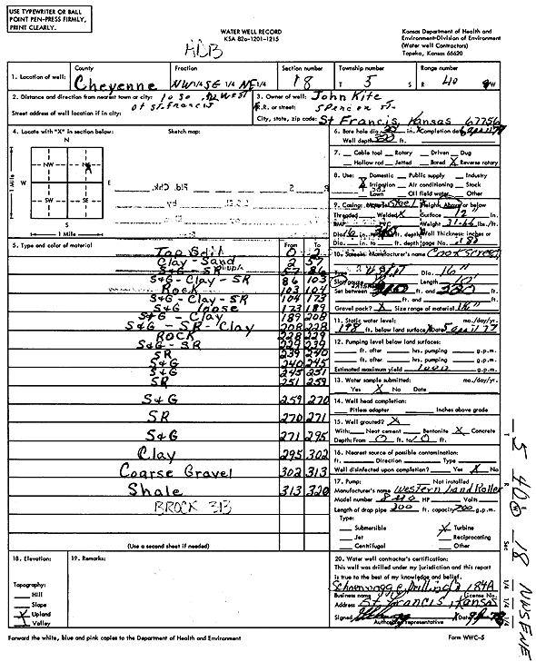
Specific Water Well Detail |
|
|
| Location Info | |||
| Owner: Kite, John | Status: Constructed | ||
| Location: T5S, R40W, Sec. 18, NW SE NE | County: Cheyenne | ||
| Directions: from St. Francis, 10 mi S and 0.5 mi W | |||
| Latitude: 39.6219701 | Longitude: -101.8472634 | Datum NAD 27 | |
| Latitude: 39.6219646 | Longitude: -101.847718 | Datum NAD 83 | |
| Longitude and latitude calculated by Survey from township-range-section-quarter calls. Only good to within the quarter call accuracy. | |||
| View well on interactive map | |||
| General Info | ||
| Well Depth: 320 ft. | Elevation: ft. | |
| Static Water Level: 198 ft. | Est. Yield: 1000 gpm. | |
| Comp. Date: 06-Apr-1978 | Well Use: Irrigation | |
| DWR Applic. #: | Other ID: | |
| Links | |
| View info from Wizard Water Level Data base... | |
| View info from WIMAS Water Right Data base... | |
| Driller Info | ||
| Driller: Schoenrogge Drilling, Inc. | License #: 184 | |
| Scanned Form | View scan |
|
Chemical Sample Submitted?: No
Water Well disinfected?: | ||
| Ground water encountered: 0 ft. , 0 ft. , 0 ft. | ||
| Pump test data: Well water was 0 ft after 0 hours pumping 0 gpm | ||
| Casing Info | ||
| Casing Type: Steel
Casing Joints: |
Diam: 16 in. to 320 ft | |
| Casing height above land surface: in
Casing Weight: lbs/ft Wall thickness or gauge no.: | ||
| Screen and Perforation Info | ||
| Screen Type: Steel | Screen Openings: | |
| Screen-perforated intervals | From: 310 ft to 320 ft | |
| Gravel pack intervals | From: ft to ft | |
| Grout Info | ||
| Grout used: | From: 0 to 0 ft
From: 0 to 0 ft From: 0 to 0 ft | |
| Source of Possible Contamination | ||
| Source: | ||
| Direction from well: | Distance: 0 ft | |
| Lithologic Log
(Log data entered by KGS.) | ||
| From: 0 ft. to 2 ft. | Top soil | |
| From: 2 ft. to 57 ft. | Clay, sand | |
| From: 57 ft. to 86 ft. | Sand and gravel, sand rock | |
| From: 86 ft. to 103 ft. | Sand and gravel, clay, sand rock | |
| From: 103 ft. to 104 ft. | Rock | |
| From: 104 ft. to 173 ft. | Sand and gravel, clay, sand rock | |
| From: 173 ft. to 189 ft. | Sand and gravel loose | |
| From: 189 ft. to 208 ft. | Sand and gravel, clay | |
| From: 208 ft. to 228 ft. | Sand and gravel, sand rock, clay | |
| From: 228 ft. to 229 ft. | Rock | |
| From: 229 ft. to 239 ft. | Sand and gravel, sand rock | |
| From: 239 ft. to 240 ft. | Sand rock | |
| From: 240 ft. to 245 ft. | Sand and gravel | |
| From: 245 ft. to 251 ft. | Sand and gravel | |
| From: 251 ft. to 259 ft. | Sand rock | |
| From: 259 ft. to 270 ft. | Sand and gravel | |
| From: 270 ft. to 271 ft. | Sand rock | |
| From: 271 ft. to 295 ft. | Sand and gravel | |
| From: 295 ft. to 302 ft. | Clay | |
| From: 302 ft. to 313 ft. | Coarse gravel | |
| From: 313 ft. to 320 ft. | Shale | |