|
|
|
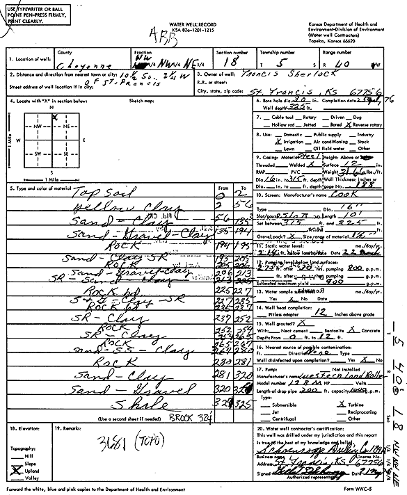
Specific Water Well Detail |
|
|
| Location Info | |||
| Owner: Sherlock, Francis | Status: Constructed | ||
| Location: T5S, R40W, Sec. 18, NW NW NE | County: Cheyenne | ||
| Directions: from St. Francis, 10.5 mi S and 2.25 mi W | |||
| Latitude: 39.6255851 | Longitude: -101.8519106 | Datum NAD 27 | |
| Latitude: 39.6255796 | Longitude: -101.8523654 | Datum NAD 83 | |
| Longitude and latitude calculated by Survey from township-range-section-quarter calls. Only good to within the quarter call accuracy. | |||
| View well on interactive map | |||
| General Info | ||
| Well Depth: 325 ft. | Elevation: ft. | |
| Static Water Level: 214 ft. | Est. Yield: 900 gpm. | |
| Comp. Date: 25-May-1976 | Well Use: Irrigation | |
| DWR Applic. #: | Other ID: | |
| Driller Info | ||
| Driller: Schoenrogge Drilling, Inc. | License #: 184 | |
| Scanned Form | View scan |
|
Chemical Sample Submitted?: No
Water Well disinfected?: | ||
| Ground water encountered: 0 ft. , 0 ft. , 0 ft. | ||
| Pump test data: Well water was 0 ft after 0 hours pumping 0 gpm | ||
| Casing Info | ||
| Casing Type:
Casing Joints: |
Diam: 0 in. to 0 ft
Diam: 0 in. to 0 ft Diam: 0 in. to 0 ft | |
| Casing height above land surface: in
Casing Weight: lbs/ft Wall thickness or gauge no.: | ||
| Screen and Perforation Info | ||
| Screen Type: | Screen Openings: | |
| Screen-perforated intervals | From: 315 ft to 325 ft
From: 0 ft to 0 ft From: 0 ft to 0 ft | |
| Gravel pack intervals | From: ft to ft | |
| Grout Info | ||
| Grout used: | From: 0 to 0 ft
From: 0 to 0 ft From: 0 to 0 ft | |
| Source of Possible Contamination | ||
| Source: | ||
| Direction from well: | Distance: 0 ft | |
| Lithologic Log
(Log data entered by KGS.) | ||
| From: 0 ft. to 2 ft. | Top soil | |
| From: 2 ft. to 56 ft. | Yellow clay | |
| From: 56 ft. to 135 ft. | Sand, clay | |
| From: 135 ft. to 194 ft. | Sand, gravel, clay | |
| From: 194 ft. to 195 ft. | Rock | |
| From: 195 ft. to 205 ft. | Sand, clay sand rock | |
| From: 205 ft. to 206 ft. | Rock | |
| From: 206 ft. to 213 ft. | Sand, gravel, clay | |
| From: 213 ft. to 225 ft. | Sand rock, sand, clay | |
| From: 225 ft. to 227 ft. | Rock hard | |
| From: 227 ft. to 235 ft. | Sand and gravel, clay, sand rock | |
| From: 235 ft. to 237 ft. | Rock | |
| From: 237 ft. to 252 ft. | Sand rock, clay | |
| From: 252 ft. to 254 ft. | Rock | |
| From: 254 ft. to 265 ft. | Sand rock, clay | |
| From: 265 ft. to 267 ft. | Rock | |
| From: 267 ft. to 280 ft. | Sand, sandstone, clay | |
| From: 280 ft. to 281 ft. | Rock | |
| From: 281 ft. to 320 ft. | Sand, clay | |
| From: 320 ft. to 324 ft. | Sand, gravel | |
| From: 324 ft. to 325 ft. | Shale | |