|
|
|
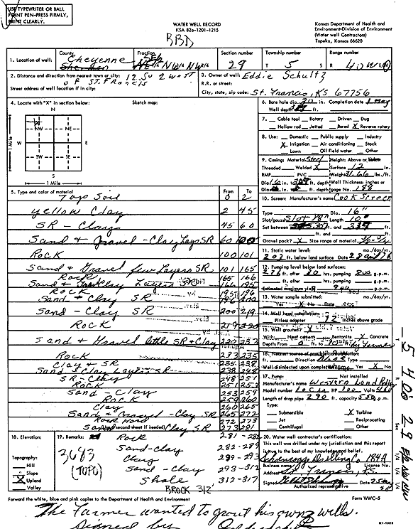
Specific Water Well Detail |
|
|
| Location Info | |||
| Owner: Schultz, Eddie | Status: Constructed | ||
| Location: T5S, R40W, Sec. 29, SE NW NW | County: Cheyenne | ||
| Directions: from St. Francis, 12 mi S and 2 mi W | |||
| Latitude: 39.5947184 | Longitude: -101.8404733 | Datum NAD 27 | |
| Latitude: 39.5947132 | Longitude: -101.8409277 | Datum NAD 83 | |
| Longitude and latitude calculated by Survey from township-range-section-quarter calls. Only good to within the quarter call accuracy. | |||
| View well on interactive map | |||
| General Info | ||
| Well Depth: 317 ft. | Elevation: ft. | |
| Static Water Level: 203 ft. | Est. Yield: 900 gpm. | |
| Comp. Date: 01-May-1976 | Well Use: Irrigation | |
| DWR Applic. #: | Other ID: | |
| Links | |
| View info from Wizard Water Level Data base... | |
| View info from WIMAS Water Right Data base... | |
| Driller Info | ||
| Driller: Schoenrogge Drilling, Inc. | License #: 184 | |
| Scanned Form | View scan |
|
Chemical Sample Submitted?: No
Water Well disinfected?: | ||
| Ground water encountered: 0 ft. , 0 ft. , 0 ft. | ||
| Pump test data: Well water was 0 ft after 0 hours pumping 0 gpm | ||
| Casing Info | ||
| Casing Type:
Casing Joints: |
Diam: 0 in. to 0 ft
Diam: 0 in. to 0 ft Diam: 0 in. to 0 ft | |
| Casing height above land surface: in
Casing Weight: lbs/ft Wall thickness or gauge no.: | ||
| Screen and Perforation Info | ||
| Screen Type: | Screen Openings: | |
| Screen-perforated intervals | From: 307 ft to 317 ft
From: 0 ft to 0 ft From: 0 ft to 0 ft | |
| Gravel pack intervals | From: ft to ft | |
| Grout Info | ||
| Grout used: | From: 0 to 0 ft
From: 0 to 0 ft From: 0 to 0 ft | |
| Source of Possible Contamination | ||
| Source: | ||
| Direction from well: | Distance: 0 ft | |
| Lithologic Log
(Log data entered by KGS.) | ||
| From: 0 ft. to 2 ft. | Top soil | |
| From: 2 ft. to 45 ft. | Yellow clay | |
| From: 45 ft. to 60 ft. | Sand rock, clay | |
| From: 60 ft. to 100 ft. | sand and gravel, clay layers sand rock | |
| From: 100 ft. to 101 ft. | Rock | |
| From: 101 ft. to 165 ft. | Sand and gravel few layers of sand rock | |
| From: 165 ft. to 166 ft. | Rock | |
| From: 166 ft. to 195 ft. | Sand and gravel and clay layers of sand rock | |
| From: 195 ft. to 196 ft. | Rock | |
| From: 196 ft. to 200 ft. | Sand and clay sand rock | |
| From: 200 ft. to 219 ft. | Sand, clay sand rock | |
| From: 219 ft. to 220 ft. | Rock | |
| From: 220 ft. to 233 ft. | Sand and gravel little sand rock and clay | |
| From: 233 ft. to 235 ft. | Rock | |
| From: 235 ft. to 238 ft. | Clay and sand rock | |
| From: 238 ft. to 248 ft. | Sand and clay layers with sand rock | |
| From: 248 ft. to 251 ft. | Sand rock, clay | |
| From: 251 ft. to 253 ft. | Rock | |
| From: 253 ft. to 259 ft. | Sand, clay | |
| From: 259 ft. to 260 ft. | Rock | |
| From: 260 ft. to 265 ft. | Clay | |
| From: 265 ft. to 272 ft. | Sand and gravel, clay sand rock | |
| From: 272 ft. to 273 ft. | Rock hard | |
| From: 273 ft. to 281 ft. | Sand, clay sand rock | |
| From: 281 ft. to 282 ft. | Rock | |
| From: 282 ft. to 289 ft. | Sand, clay | |
| From: 289 ft. to 293 ft. | Clay | |
| From: 293 ft. to 312 ft. | Sand, clay | |
| From: 312 ft. to 317 ft. | Shale | |