|
|
|
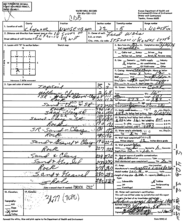
Specific Water Well Detail |
|
|
| Location Info | |||
| Owner: Weis, Fred | Status: Constructed | ||
| Location: T5S, R40W, Sec. 32, NW SE SW | County: Cheyenne | ||
| Directions: from St. Francis, 14 mi S and 1.5 mi W | |||
| Latitude: 39.5711426 | Longitude: -101.8384434 | Datum NAD 27 | |
| Latitude: 39.5711377 | Longitude: -101.8388977 | Datum NAD 83 | |
| Longitude and latitude calculated by Survey from township-range-section-quarter calls. Only good to within the quarter call accuracy. | |||
| View well on interactive map | |||
| General Info | ||
| Well Depth: 283 ft. | Elevation: ft. | |
| Static Water Level: 149 ft. | Est. Yield: 1000 gpm. | |
| Comp. Date: 21-Sep-1976 | Well Use: Irrigation | |
| DWR Applic. #: | Other ID: | |
| Links | |
| View info from Wizard Water Level Data base... | |
| View info from WIMAS Water Right Data base... | |
| Driller Info | ||
| Driller: Schoenrogge Drilling, Inc. | License #: 184 | |
| Scanned Form | View scan |
|
Chemical Sample Submitted?: No
Water Well disinfected?: | ||
| Ground water encountered: 0 ft. , 0 ft. , 0 ft. | ||
| Pump test data: Well water was 0 ft after 0 hours pumping 0 gpm | ||
| Casing Info | ||
| Casing Type:
Casing Joints: |
Diam: 0 in. to 0 ft
Diam: 0 in. to 0 ft Diam: 0 in. to 0 ft | |
| Casing height above land surface: in
Casing Weight: lbs/ft Wall thickness or gauge no.: | ||
| Screen and Perforation Info | ||
| Screen Type: | Screen Openings: | |
| Screen-perforated intervals | From: 273 ft to 283 ft
From: 0 ft to 0 ft From: 0 ft to 0 ft | |
| Gravel pack intervals | From: ft to ft | |
| Grout Info | ||
| Grout used: | From: 0 to 0 ft
From: 0 to 0 ft From: 0 to 0 ft | |
| Source of Possible Contamination | ||
| Source: | ||
| Direction from well: | Distance: 0 ft | |
| Lithologic Log
(Log data entered by KGS.) | ||
| From: 0 ft. to 2 ft. | Top soil | |
| From: 2 ft. to 68 ft. | Yellow clay | |
| From: 68 ft. to 111 ft. | Sand rock, sand and gravel, clay | |
| From: 111 ft. to 112 ft. | Rock | |
| From: 112 ft. to 140 ft. | Sand, clay and sand rock | |
| From: 140 ft. to 141 ft. | Rock | |
| From: 141 ft. to 150 ft. | Sand, clay sand rock | |
| From: 150 ft. to 151 ft. | Rock | |
| From: 151 ft. to 190 ft. | Sand, clay, sand rock | |
| From: 190 ft. to 191 ft. | Rock | |
| From: 191 ft. to 195 ft. | Sand rock, sand, clay | |
| From: 195 ft. to 196 ft. | Rock | |
| From: 196 ft. to 227 ft. | Sand and gravel and clay | |
| From: 227 ft. to 229 ft. | Rock | |
| From: 229 ft. to 270 ft. | Sand and clay | |
| From: 270 ft. to 278 ft. | Sand and gravel | |
| From: 278 ft. to 280 ft. | Rock | |
| From: 280 ft. to 282 ft. | Sand and gravel | |
| From: 282 ft. to 283 ft. | Shale | |