|
|
|
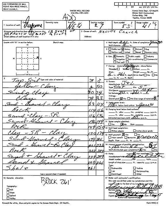
Specific Water Well Detail |
|
|
| Location Info | |||
| Owner: Neville Church | Status: Constructed | ||
| Location: T5S, R41W, Sec. 27, SE SE NE | County: Cheyenne | ||
| Directions: from St. Francis, 12 mi S, 5 mi W, and 0.5 mi S | |||
| Latitude: 39.5911067 | Longitude: -101.901228 | Datum NAD 27 | |
| Latitude: 39.5911014 | Longitude: -101.9016846 | Datum NAD 83 | |
| Longitude and latitude calculated by Survey from township-range-section-quarter calls. Only good to within the quarter call accuracy. | |||
| View well on interactive map | |||
| General Info | ||
| Well Depth: 261 ft. | Elevation: ft. | |
| Static Water Level: 198 ft. | Est. Yield: 20 gpm. | |
| Comp. Date: 30-Jun-1975 | Well Use: Domestic | |
| DWR Applic. #: | Other ID: | |
| Driller Info | ||
| Driller: Schoenrogge Drilling, Inc. | License #: 184 | |
| Scanned Form | View scan |
|
Chemical Sample Submitted?: No
Water Well disinfected?: | ||
| Ground water encountered: 0 ft. , 0 ft. , 0 ft. | ||
| Pump test data: Well water was 0 ft after 0 hours pumping 0 gpm | ||
| Casing Info | ||
| Casing Type:
Casing Joints: |
Diam: 0 in. to 0 ft
Diam: 0 in. to 0 ft Diam: 0 in. to 0 ft | |
| Casing height above land surface: in
Casing Weight: lbs/ft Wall thickness or gauge no.: | ||
| Screen and Perforation Info | ||
| Screen Type: | Screen Openings: | |
| Screen-perforated intervals | From: 251 ft to 261 ft
From: 0 ft to 0 ft From: 0 ft to 0 ft | |
| Gravel pack intervals | From: ft to ft | |
| Grout Info | ||
| Grout used: | From: 0 to 0 ft
From: 0 to 0 ft From: 0 to 0 ft | |
| Source of Possible Contamination | ||
| Source: | ||
| Direction from well: | Distance: 0 ft | |
| Lithologic Log
(Log data entered by KGS.) | ||
| From: 0 ft. to 2 ft. | Top soil | |
| From: 2 ft. to 50 ft. | Yellow clay | |
| From: 50 ft. to 74 ft. | Sandy clay | |
| From: 74 ft. to 83 ft. | Clay | |
| From: 83 ft. to 114 ft. | Sand, gravel, clay | |
| From: 114 ft. to 116 ft. | Rock | |
| From: 116 ft. to 136 ft. | Sand, clay, sand rock | |
| From: 136 ft. to 149 ft. | Sand, gravel, clay | |
| From: 149 ft. to 150 ft. | Rock | |
| From: 150 ft. to 179 ft. | Clay, sand rock, clay | |
| From: 179 ft. to 201 ft. | Sand, gravel, clay | |
| From: 201 ft. to 222 ft. | Sand, gravel, brown clay | |
| From: 222 ft. to 224 ft. | Rock | |
| From: 224 ft. to 249 ft. | Sand and gravel and clay | |
| From: 249 ft. to 261 ft. | Sand and gravel | |
| From: 261 ft. to ft. | Shale | |