|
|
|
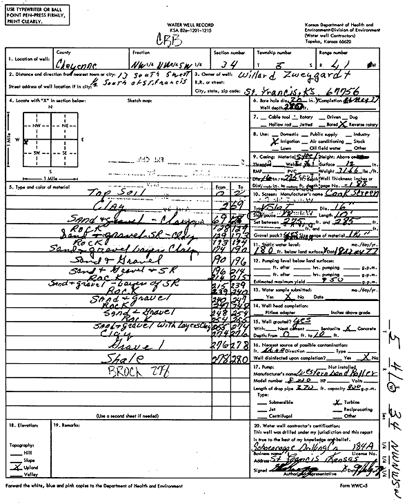
Specific Water Well Detail |
|
|
| Location Info | |||
| Owner: Zweygardt, Willard | Status: Constructed | ||
| Location: T5S, R41W, Sec. 34, NW NW SW | County: Cheyenne | ||
| Directions: from St. Francis, 13 mi S, 5 mi W, and 0.5 mi S | |||
| Latitude: 39.5747585 | Longitude: -101.9177145 | Datum NAD 27 | |
| Latitude: 39.5747533 | Longitude: -101.9181716 | Datum NAD 83 | |
| Longitude and latitude calculated by Survey from township-range-section-quarter calls. Only good to within the quarter call accuracy. | |||
| View well on interactive map | |||
| General Info | ||
| Well Depth: 280 ft. | Elevation: ft. | |
| Static Water Level: 180 ft. | Est. Yield: 950 gpm. | |
| Comp. Date: 21-May-1977 | Well Use: Irrigation | |
| DWR Applic. #: | Other ID: | |
| Links | |
| View info from Wizard Water Level Data base... | |
| View info from WIMAS Water Right Data base... | |
| Driller Info | ||
| Driller: Schoenrogge Drilling, Inc. | License #: 184 | |
| Scanned Form | View scan |
|
Chemical Sample Submitted?: No
Water Well disinfected?: | ||
| Ground water encountered: 0 ft. , 0 ft. , 0 ft. | ||
| Pump test data: Well water was 0 ft after 0 hours pumping 0 gpm | ||
| Casing Info | ||
| Casing Type: Steel
Casing Joints: |
Diam: 16 in. to 275 ft | |
| Casing height above land surface: in
Casing Weight: lbs/ft Wall thickness or gauge no.: | ||
| Screen and Perforation Info | ||
| Screen Type: Steel | Screen Openings: | |
| Screen-perforated intervals | From: 275 ft to 285 ft | |
| Gravel pack intervals | From: ft to ft | |
| Grout Info | ||
| Grout used: | From: 0 to 0 ft
From: 0 to 0 ft From: 0 to 0 ft | |
| Source of Possible Contamination | ||
| Source: | ||
| Direction from well: | Distance: 0 ft | |
| Lithologic Log
(Log data entered by KGS.) | ||
| From: 0 ft. to 2 ft. | Top soil | |
| From: 2 ft. to 69 ft. | Clay | |
| From: 69 ft. to 128 ft. | Sand and gravel, clay | |
| From: 128 ft. to 129 ft. | Rock | |
| From: 129 ft. to 173 ft. | Sand and gravel, sand rock, clay | |
| From: 173 ft. to 174 ft. | Rock | |
| From: 174 ft. to 190 ft. | Sand and gravel layers of clay | |
| From: 190 ft. to 196 ft. | Sand and gravel | |
| From: 196 ft. to 214 ft. | Sand and gravel and sand rock | |
| From: 214 ft. to 215 ft. | Rock | |
| From: 215 ft. to 239 ft. | Sand and gravel, layers of sand rock | |
| From: 239 ft. to 240 ft. | Rock | |
| From: 240 ft. to 247 ft. | Sand and gravel | |
| From: 247 ft. to 248 ft. | Rock | |
| From: 248 ft. to 254 ft. | Sand and gravel | |
| From: 254 ft. to 255 ft. | Rock | |
| From: 255 ft. to 274 ft. | Sand and gravel with layers of clay | |
| From: 274 ft. to 276 ft. | Clay | |
| From: 276 ft. to 278 ft. | Gravel | |
| From: 278 ft. to 280 ft. | Shale | |