|
|
|
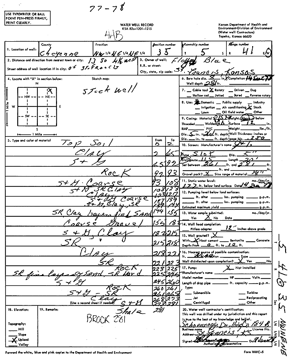
Specific Water Well Detail |
|
|
| Location Info | |||
| Owner: Blue, Floyd | Status: Constructed | ||
| Location: T5S, R41W, Sec. 35, NW NE NE | County: Cheyenne | ||
| Directions: from St. Francis, 13 mi S and 4.5 mi W | |||
| Latitude: 39.5820023 | Longitude: -101.8848641 | Datum NAD 27 | |
| Latitude: 39.5819972 | Longitude: -101.8853201 | Datum NAD 83 | |
| Longitude and latitude calculated by Survey from township-range-section-quarter calls. Only good to within the quarter call accuracy. | |||
| View well on interactive map | |||
| General Info | ||
| Well Depth: 281 ft. | Elevation: ft. | |
| Static Water Level: 177 ft. | Est. Yield: gpm. | |
| Comp. Date: 14-Sep-1978 | Well Use: Domestic, Livestock | |
| DWR Applic. #: | Other ID: | |
| Driller Info | ||
| Driller: Schoenrogge Drilling, Inc. | License #: 184 | |
| Scanned Form | View scan |
|
Chemical Sample Submitted?: No
Water Well disinfected?: | ||
| Ground water encountered: 0 ft. , 0 ft. , 0 ft. | ||
| Pump test data: Well water was 0 ft after 0 hours pumping 0 gpm | ||
| Casing Info | ||
| Casing Type:
Casing Joints: |
Diam: 0 in. to 0 ft
Diam: 0 in. to 0 ft Diam: 0 in. to 0 ft | |
| Casing height above land surface: in
Casing Weight: lbs/ft Wall thickness or gauge no.: | ||
| Screen and Perforation Info | ||
| Screen Type: | Screen Openings: | |
| Screen-perforated intervals | From: 261 ft to 281 ft
From: 0 ft to 0 ft From: 0 ft to 0 ft | |
| Gravel pack intervals | From: ft to ft | |
| Grout Info | ||
| Grout used: | From: 0 to 0 ft
From: 0 to 0 ft From: 0 to 0 ft | |
| Source of Possible Contamination | ||
| Source: | ||
| Direction from well: | Distance: 0 ft | |
| Lithologic Log
(Log data entered by KGS.) | ||
| From: 0 ft. to 2 ft. | Top soil | |
| From: 2 ft. to 65 ft. | Clay | |
| From: 65 ft. to 92 ft. | Sand and gravel | |
| From: 92 ft. to 93 ft. | Rock | |
| From: 93 ft. to 108 ft. | Sand and gravel coarse | |
| From: 108 ft. to 123 ft. | Sand and gravel, sand rock, clay | |
| From: 123 ft. to 127 ft. | Clay | |
| From: 127 ft. to 139 ft. | Sand and gravel coarse | |
| From: 139 ft. to 144 ft. | Sand and gravel, clay, sand rock | |
| From: 144 ft. to 155 ft. | Sand rock, clay, layers of find sand | |
| From: 155 ft. to 182 ft. | Coarse gravel | |
| From: 182 ft. to 215 ft. | Sand and gravel, clay | |
| From: 215 ft. to 218 ft. | Sand rock | |
| From: 218 ft. to 221 ft. | Clay | |
| From: 221 ft. to 223 ft. | Sand rock | |
| From: 223 ft. to 225 ft. | Rock | |
| From: 225 ft. to 245 ft. | Sand rock, fine layers of sand, sand rock hard | |
| From: 245 ft. to 260 ft. | Sand and gravel | |
| From: 260 ft. to 261 ft. | Rock | |
| From: 261 ft. to 268 ft. | Sand and gravel, sand rock | |
| From: 268 ft. to 273 ft. | Clay | |
| From: 273 ft. to 281 ft. | Sand and gravel | |
| From: 281 ft. to ft. | Shale | |