|
|
|
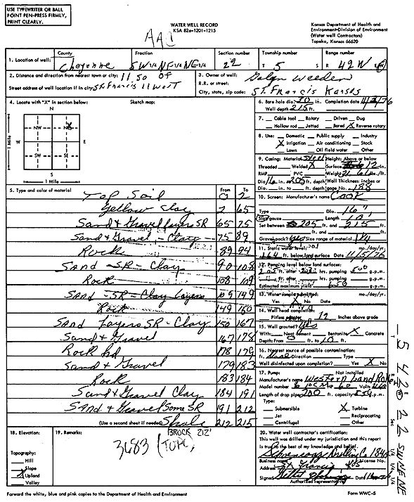
Specific Water Well Detail |
|
|
| Location Info | |||
| Owner: Weeden, Galen | Status: Constructed | ||
| Location: T5S, R42W, Sec. 22, SW NE NE | County: Cheyenne | ||
| Directions: from St. Francis, 11 mi S and 11 mi W | |||
| Latitude: 39.6088448 | Longitude: -102.0158232 | Datum NAD 27 | |
| Latitude: 39.6088391 | Longitude: -102.016284 | Datum NAD 83 | |
| Longitude and latitude calculated by Survey from township-range-section-quarter calls. Only good to within the quarter call accuracy. | |||
| View well on interactive map | |||
| General Info | ||
| Well Depth: 215 ft. | Elevation: ft. | |
| Static Water Level: 164 ft. | Est. Yield: 650 gpm. | |
| Comp. Date: 03-Nov-1976 | Well Use: Irrigation | |
| DWR Applic. #: | Other ID: | |
| Links | |
| View info from Wizard Water Level Data base... | |
| View info from WIMAS Water Right Data base... | |
| Driller Info | ||
| Driller: Schoenrogge Drilling, Inc. | License #: 184 | |
| Scanned Form | View scan |
|
Chemical Sample Submitted?: No
Water Well disinfected?: | ||
| Ground water encountered: 0 ft. , 0 ft. , 0 ft. | ||
| Pump test data: Well water was 0 ft after 0 hours pumping 0 gpm | ||
| Casing Info | ||
| Casing Type:
Casing Joints: |
Diam: 0 in. to 0 ft
Diam: 0 in. to 0 ft Diam: 0 in. to 0 ft | |
| Casing height above land surface: in
Casing Weight: lbs/ft Wall thickness or gauge no.: | ||
| Screen and Perforation Info | ||
| Screen Type: | Screen Openings: | |
| Screen-perforated intervals | From: 205 ft to 215 ft
From: 0 ft to 0 ft From: 0 ft to 0 ft | |
| Gravel pack intervals | From: ft to ft | |
| Grout Info | ||
| Grout used: | From: 0 to 0 ft
From: 0 to 0 ft From: 0 to 0 ft | |
| Source of Possible Contamination | ||
| Source: | ||
| Direction from well: | Distance: 0 ft | |
| Lithologic Log
(Log data entered by KGS.) | ||
| From: 0 ft. to 2 ft. | Topsoil | |
| From: 2 ft. to 65 ft. | Yellow clay | |
| From: 65 ft. to 74 ft. | Sand and gravel, layers of sand rock | |
| From: 74 ft. to 89 ft. | Sand and gravel, clay | |
| From: 89 ft. to 94 ft. | Rock | |
| From: 94 ft. to 108 ft. | Sand, sand rock, clay | |
| From: 108 ft. to 109 ft. | Rock | |
| From: 109 ft. to 149 ft. | Sand, sandrock, clay layers | |
| From: 149 ft. to 150 ft. | Rock | |
| From: 150 ft. to 167 ft. | Sand, sand rock layers, clay | |
| From: 167 ft. to 178 ft. | Sand and gravel | |
| From: 178 ft. to 179 ft. | Rock hard | |
| From: 179 ft. to 183 ft. | Sand and gravel | |
| From: 183 ft. to 184 ft. | Rock | |
| From: 184 ft. to 191 ft. | Sand and gravel, clay | |
| From: 191 ft. to 212 ft. | Sand and gravel, some sand rock | |
| From: 212 ft. to 215 ft. | Shale | |