|
|
|
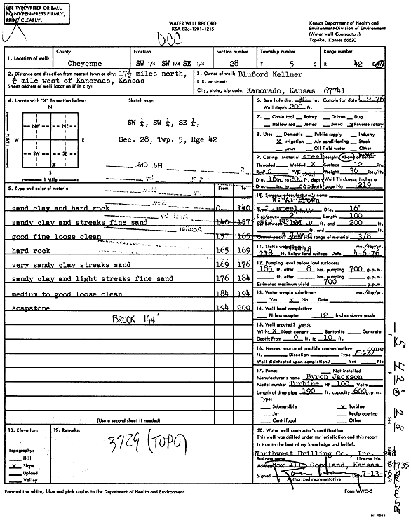
Specific Water Well Detail |
|
|
| Location Info | |||
| Owner: Kellner, Bluford | Status: Constructed | ||
| Location: T5S, R42W, Sec. 28, SW SW SE | County: Cheyenne | ||
| Directions: from Kanorado, 17.5 mi N and 0.25 mi W | |||
| Latitude: 39.5835168 | Longitude: -102.0391734 | Datum NAD 27 | |
| Latitude: 39.5835112 | Longitude: -102.039635 | Datum NAD 83 | |
| Longitude and latitude calculated by Survey from township-range-section-quarter calls. Only good to within the quarter call accuracy. | |||
| View well on interactive map | |||
| General Info | ||
| Well Depth: 200 ft. | Elevation: ft. | |
| Static Water Level: 118 ft. | Est. Yield: 700 gpm. | |
| Comp. Date: 02-Apr-1976 | Well Use: Irrigation | |
| DWR Applic. #: | Other ID: | |
| Links | |
| View info from Wizard Water Level Data base... | |
| View info from WIMAS Water Right Data base... | |
| Driller Info | ||
| Driller: Northwest Drilling Co., Inc. | License #: 248 | |
| Scanned Form | View scan |
|
Chemical Sample Submitted?: No
Water Well disinfected?: | ||
| Ground water encountered: 0 ft. , 0 ft. , 0 ft. | ||
| Pump test data: Well water was 0 ft after 0 hours pumping 0 gpm | ||
| Casing Info | ||
| Casing Type:
Casing Joints: |
Diam: 0 in. to 0 ft
Diam: 0 in. to 0 ft Diam: 0 in. to 0 ft | |
| Casing height above land surface: in
Casing Weight: lbs/ft Wall thickness or gauge no.: | ||
| Screen and Perforation Info | ||
| Screen Type: | Screen Openings: | |
| Screen-perforated intervals | From: 100 ft to 200 ft
From: 0 ft to 0 ft From: 0 ft to 0 ft | |
| Gravel pack intervals | From: ft to ft | |
| Grout Info | ||
| Grout used: | From: 0 to 0 ft
From: 0 to 0 ft From: 0 to 0 ft | |
| Source of Possible Contamination | ||
| Source: | ||
| Direction from well: | Distance: 0 ft | |
| Lithologic Log
(Log data entered by KGS.) | ||
| From: 0 ft. to 140 ft. | Sand clay and hard rock | |
| From: 140 ft. to 157 ft. | Sandy clay and streaks fine sand | |
| From: 157 ft. to 165 ft. | Good fine loose clean | |
| From: 165 ft. to 169 ft. | Hard rock | |
| From: 169 ft. to 176 ft. | Very sandy clay streaks sand | |
| From: 176 ft. to 184 ft. | Sandy clay and light streaks fine sand | |
| From: 184 ft. to 194 ft. | Medium to good loose clean | |
| From: 194 ft. to 200 ft. | Soapstone | |