|
|
|
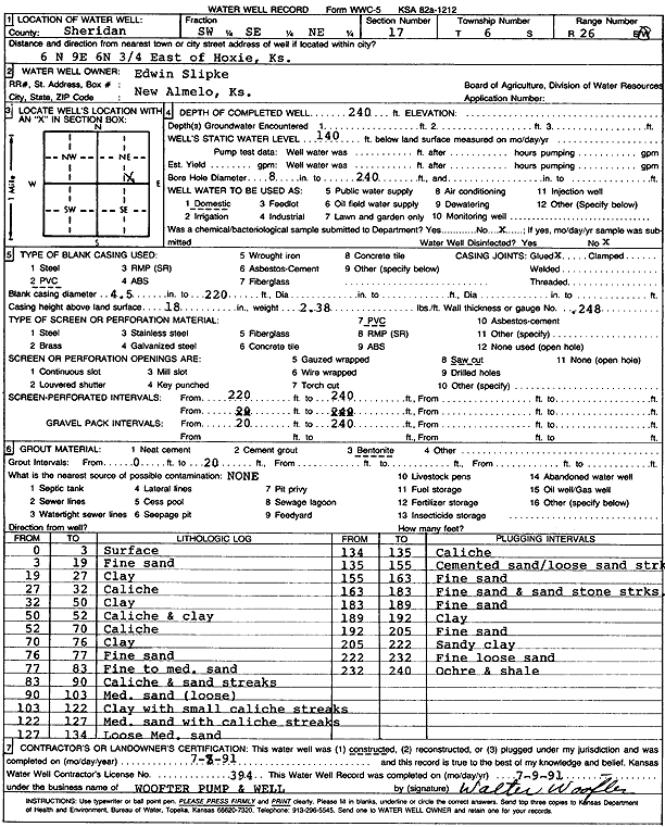
Specific Water Well Detail |
|
|
| Location Info | |||
| Owner: Slipke, Edwin | Status: Constructed | ||
| Location: T6S, R26W, Sec. 17, SW SE NE | County: Sheridan | ||
| Directions: from Hoxie: 6 mi N, 9 mi E, 6 mi N, .75 mi E | |||
| Latitude: 39.5316684 | Longitude: -100.2399662 | Datum NAD 27 | |
| Latitude: 39.5316719 | Longitude: -100.2403811 | Datum NAD 83 | |
| Longitude and latitude calculated by Survey from township-range-section-quarter calls. Only good to within the quarter call accuracy. | |||
| View well on interactive map | |||
| General Info | ||
| Well Depth: 240 ft. | Elevation: ft. | |
| Static Water Level: 140 ft. | Est. Yield: gpm. | |
| Comp. Date: 08-Jul-1991 | Well Use: Domestic | |
| DWR Applic. #: | Other ID: | |
| Driller Info | ||
| Driller: Walter Woofter Pump & Well | License #: 394 | |
| Scanned Form | View scan |
|
Chemical Sample Submitted?: No
Water Well disinfected?: | ||
| Ground water encountered: 0 ft. , 0 ft. , 0 ft. | ||
| Pump test data: Well water was 0 ft after 0 hours pumping 0 gpm | ||
| Casing Info | ||
| Casing Type: PVC
Casing Joints: |
Diam: 4 in. to 220 ft
Diam: 0 in. to 0 ft Diam: 0 in. to 0 ft | |
| Casing height above land surface: in
Casing Weight: lbs/ft Wall thickness or gauge no.: | ||
| Screen and Perforation Info | ||
| Screen Type: PVC | Screen Openings: Saw cut | |
| Screen-perforated intervals | From: 220 ft to 240 ft
From: 0 ft to 0 ft From: 0 ft to 0 ft | |
| Gravel pack intervals | From: ft to ft | |
| Grout Info | ||
| Grout used: Bentonite | From: 0 to 20 ft
From: 0 to 0 ft From: 0 to 0 ft | |
| Source of Possible Contamination | ||
| Source: OTHER | ||
| Direction from well: | Distance: 0 ft | |
| Lithologic Log
(Log data entered by KGS.) | ||
| From: 0 ft. to 3 ft. | Surface | |
| From: 3 ft. to 19 ft. | Fine sand | |
| From: 19 ft. to 27 ft. | Clay | |
| From: 27 ft. to 32 ft. | Caliche | |
| From: 32 ft. to 50 ft. | Clay | |
| From: 50 ft. to 52 ft. | Caliche and clay | |
| From: 52 ft. to 70 ft. | Caliche | |
| From: 70 ft. to 76 ft. | Clay | |
| From: 76 ft. to 77 ft. | Fine sand | |
| From: 77 ft. to 83 ft. | Fine to medium sand | |
| From: 83 ft. to 90 ft. | Caliche and sand streaks | |
| From: 90 ft. to 103 ft. | Medium sand loose | |
| From: 103 ft. to 122 ft. | Clay with small caliche streaks | |
| From: 122 ft. to 127 ft. | Medium sand with caliche streaks | |
| From: 127 ft. to 134 ft. | Loose medium sand | |
| From: 134 ft. to 135 ft. | Caliche | |
| From: 135 ft. to 155 ft. | Cemented sand, loose sand streak | |
| From: 155 ft. to 163 ft. | Fine sand | |
| From: 163 ft. to 183 ft. | Fine sand and sandstone streaks | |
| From: 183 ft. to 189 ft. | Fine sand | |
| From: 189 ft. to 192 ft. | Clay | |
| From: 192 ft. to 205 ft. | Fine sand | |
| From: 205 ft. to 222 ft. | Sandy clay | |
| From: 222 ft. to 232 ft. | Fine loose sand | |
| From: 232 ft. to 240 ft. | Ochre and shale | |