|
|
|
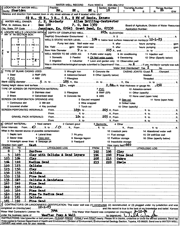
Specific Water Well Detail |
|
|
| Location Info | |||
| Owner: Allen Drilling | Status: Constructed | ||
| Location: T6S, R26W, Sec. 18, NW SE SE | County: Sheridan | ||
| Directions: from Hoxie: 6.5 mi E, 5.5 mi N, 3 mi E, 6 mi N, .25 mi NW | |||
| Latitude: 39.5262235 | Longitude: -100.2586712 | Datum NAD 27 | |
| Latitude: 39.5262269 | Longitude: -100.2590866 | Datum NAD 83 | |
| Longitude and latitude calculated by Survey from township-range-section-quarter calls. Only good to within the quarter call accuracy. | |||
| View well on interactive map | |||
| General Info | ||
| Well Depth: 205 ft. | Elevation: ft. | |
| Static Water Level: 104 ft. | Est. Yield: gpm. | |
| Comp. Date: 01-Dec-1983 | Well Use: Oil Field Water Supply | |
| DWR Applic. #: | Other ID: | |
| Driller Info | ||
| Driller: Walter Woofter Pump & Well | License #: 394 | |
| Scanned Form | View scan |
|
Chemical Sample Submitted?: No
Water Well disinfected?: | ||
| Ground water encountered: 0 ft. , 0 ft. , 0 ft. | ||
| Pump test data: Well water was 0 ft after 0 hours pumping 0 gpm | ||
| Casing Info | ||
| Casing Type: PVC
Casing Joints: |
Diam: 5 in. to 185 ft
Diam: 0 in. to 0 ft Diam: 0 in. to 0 ft | |
| Casing height above land surface: in
Casing Weight: lbs/ft Wall thickness or gauge no.: | ||
| Screen and Perforation Info | ||
| Screen Type: PVC | Screen Openings: Saw cut | |
| Screen-perforated intervals | From: 185 ft to 205 ft
From: 0 ft to 0 ft From: 0 ft to 0 ft | |
| Gravel pack intervals | From: ft to ft | |
| Grout Info | ||
| Grout used: Bentonite | From: 0 to 10 ft
From: 0 to 0 ft From: 0 to 0 ft | |
| Source of Possible Contamination | ||
| Source: Cess pool | ||
| Direction from well: | Distance: 0 ft | |
| Lithologic Log
(Log data entered by KGS.) | ||
| From: 0 ft. to 3 ft. | Surface | |
| From: 3 ft. to 103 ft. | Clay with caliche and sand layers | |
| From: 103 ft. to 104 ft. | Clay | |
| From: 104 ft. to 120 ft. | Medium sand | |
| From: 120 ft. to 123 ft. | Caliche | |
| From: 123 ft. to 130 ft. | Clay | |
| From: 130 ft. to 133 ft. | Caliche | |
| From: 133 ft. to 135 ft. | Fine sand | |
| From: 135 ft. to 147 ft. | Caliche and sandstone | |
| From: 147 ft. to 149 ft. | Fine sand | |
| From: 149 ft. to 150 ft. | Caliche | |
| From: 150 ft. to 160 ft. | Fine sand | |
| From: 160 ft. to 165 ft. | Fine to medium sand | |
| From: 165 ft. to 181 ft. | Caliche | |
| From: 181 ft. to 192 ft. | Fine sand | |
| From: 192 ft. to 196 ft. | Clay | |
| From: 196 ft. to 208 ft. | Fine sand | |
| From: 208 ft. to 215 ft. | Ochre | |
| From: 215 ft. to 220 ft. | Shale | |