|
|
|
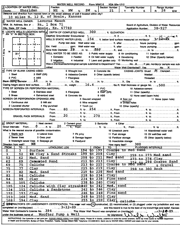
Specific Water Well Detail |
|
|
| Location Info | |||
| Owner: Mauch, Laverne | Status: Constructed | ||
| Location: T6S, R26W, Sec. 21, NE NW SW | County: Sheridan | ||
| Directions: from Hoxie: 10 mi N, 12 mi E | |||
| Latitude: 39.5153801 | Longitude: -100.2330763 | Datum NAD 27 | |
| Latitude: 39.5153835 | Longitude: -100.2334908 | Datum NAD 83 | |
| Longitude and latitude calculated by Survey from township-range-section-quarter calls. Only good to within the quarter call accuracy. | |||
| View well on interactive map | |||
| General Info | ||
| Well Depth: 300 ft. | Elevation: ft. | |
| Static Water Level: 154 ft. | Est. Yield: gpm. | |
| Comp. Date: 12-Mar-1989 | Well Use: Irrigation | |
| DWR Applic. #: 38-927 | Other ID: | |
| Links | |
| No Wizard information available. | |
| View info from WIMAS Water Right Data base... | |
| Driller Info | ||
| Driller: Walter Woofter Pump & Well | License #: 394 | |
| Scanned Form | View scan |
|
Chemical Sample Submitted?: No
Water Well disinfected?: | ||
| Ground water encountered: 0 ft. , 0 ft. , 0 ft. | ||
| Pump test data: Well water was 0 ft after 0 hours pumping 0 gpm | ||
| Casing Info | ||
| Casing Type: PVC
Casing Joints: |
Diam: 16 in. to 0 ft
Diam: 0 in. to 0 ft Diam: 0 in. to 0 ft | |
| Casing height above land surface: in
Casing Weight: lbs/ft Wall thickness or gauge no.: | ||
| Screen and Perforation Info | ||
| Screen Type: PVC | Screen Openings: Saw cut | |
| Screen-perforated intervals | From: 80 ft to 154 ft
From: 0 ft to 0 ft From: 0 ft to 0 ft | |
| Gravel pack intervals | From: ft to ft | |
| Grout Info | ||
| Grout used: Cement grout | From: 0 to 20 ft
From: 0 to 0 ft From: 0 to 0 ft | |
| Source of Possible Contamination | ||
| Source: | ||
| Direction from well: | Distance: 0 ft | |
| Lithologic Log
(Log data entered by KGS.) | ||
| From: 0 ft. to 3 ft. | Surface | |
| From: 3 ft. to 52 ft. | Clay and sand streaks | |
| From: 52 ft. to 62 ft. | Medium sand | |
| From: 62 ft. to 69 ft. | Cemented sand | |
| From: 69 ft. to 75 ft. | Caliche | |
| From: 75 ft. to 77 ft. | Clay | |
| From: 77 ft. to 82 ft. | Medium sand | |
| From: 82 ft. to 94 ft. | Caliche | |
| From: 94 ft. to 99 ft. | Clay | |
| From: 99 ft. to 105 ft. | Caliche | |
| From: 105 ft. to 124 ft. | Caliche with clay streaks | |
| From: 124 ft. to 152 ft. | Caliche and sandstone | |
| From: 152 ft. to 153 ft. | Clay | |
| From: 153 ft. to 168 ft. | Medium sand | |
| From: 168 ft. to 194 ft. | Clay | |
| From: 194 ft. to 199 ft. | Coarse to medium sand | |
| From: 199 ft. to 208 ft. | Clay | |
| From: 208 ft. to 211 ft. | Medium sand | |
| From: 211 ft. to 213 ft. | Clay | |
| From: 213 ft. to 215 ft. | Coarse to medium sand | |
| From: 215 ft. to 219 ft. | Clay | |
| From: 219 ft. to 228 ft. | Medium sand | |
| From: 228 ft. to 234 ft. | Clay | |
| From: 234 ft. to 238 ft. | Fine sand | |
| From: 238 ft. to 240 ft. | Clay | |
| From: 240 ft. to 242 ft. | Medium sand | |
| From: 242 ft. to 246 ft. | Clay | |
| From: 246 ft. to 248 ft. | Fine sand | |
| From: 248 ft. to 255 ft. | Clay | |
| From: 255 ft. to 259 ft. | Clay and caliche | |
| From: 259 ft. to 273 ft. | Medium sand | |
| From: 273 ft. to 274 ft. | Clay | |
| From: 274 ft. to 298 ft. | Coarse sand and gravel | |
| From: 298 ft. to 300 ft. | Rock | |