|
|
|
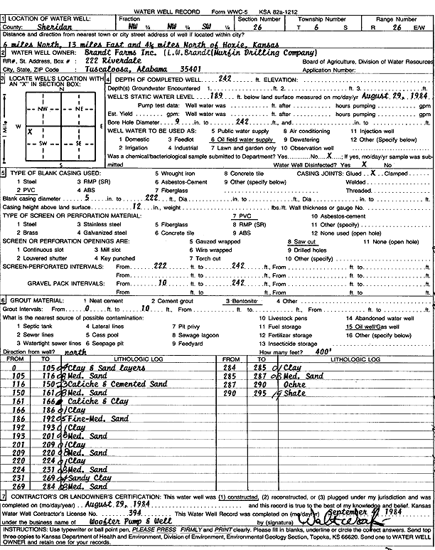
Specific Water Well Detail |
|
|
| Location Info | |||
| Owner: Murfin Drilling Co./L. W. Brandt | Status: Constructed | ||
| Location: T6S, R26W, Sec. 26, NW NW SW | County: Sheridan | ||
| Directions: from Hoxie: 6 mi N, 13 mi E, 4.5 mi N | |||
| Latitude: 39.5008978 | Longitude: -100.1980315 | Datum NAD 27 | |
| Latitude: 39.5009013 | Longitude: -100.1984444 | Datum NAD 83 | |
| Longitude and latitude calculated by Survey from township-range-section-quarter calls. Only good to within the quarter call accuracy. | |||
| View well on interactive map | |||
| General Info | ||
| Well Depth: 242 ft. | Elevation: ft. | |
| Static Water Level: 189 ft. | Est. Yield: gpm. | |
| Comp. Date: 29-Aug-1984 | Well Use: Oil Field Water Supply | |
| DWR Applic. #: | Other ID: | |
| Driller Info | ||
| Driller: Walter Woofter Pump & Well | License #: 394 | |
| Scanned Form | View scan |
|
Chemical Sample Submitted?: No
Water Well disinfected?: | ||
| Ground water encountered: 0 ft. , 0 ft. , 0 ft. | ||
| Pump test data: Well water was 0 ft after 0 hours pumping 0 gpm | ||
| Casing Info | ||
| Casing Type: PVC
Casing Joints: |
Diam: 5 in. to 222 ft
Diam: 0 in. to 0 ft Diam: 0 in. to 0 ft | |
| Casing height above land surface: in
Casing Weight: lbs/ft Wall thickness or gauge no.: | ||
| Screen and Perforation Info | ||
| Screen Type: PVC | Screen Openings: Saw cut | |
| Screen-perforated intervals | From: 222 ft to 242 ft
From: 0 ft to 0 ft From: 0 ft to 0 ft | |
| Gravel pack intervals | From: ft to ft | |
| Grout Info | ||
| Grout used: Bentonite | From: 0 to 10 ft
From: 0 to 0 ft From: 0 to 0 ft | |
| Source of Possible Contamination | ||
| Source: Oil well/gas well | ||
| Direction from well: | Distance: 0 ft | |
| Lithologic Log
(Log data entered by KGS.) | ||
| From: 0 ft. to 105 ft. | Clay and sand layers | |
| From: 105 ft. to 116 ft. | Medium sand | |
| From: 116 ft. to 150 ft. | Caliche and cemented sand | |
| From: 150 ft. to 161 ft. | Medium sand | |
| From: 161 ft. to 166 ft. | Caliche and clay | |
| From: 166 ft. to 186 ft. | Clay | |
| From: 186 ft. to 192 ft. | Fine to medium sand | |
| From: 192 ft. to 193 ft. | Clay | |
| From: 193 ft. to 201 ft. | Medium sand | |
| From: 201 ft. to 209 ft. | Clay | |
| From: 209 ft. to 220 ft. | Medium sand | |
| From: 220 ft. to 224 ft. | Clay | |
| From: 224 ft. to 231 ft. | Medium sand | |
| From: 231 ft. to 269 ft. | Sandy clay | |
| From: 269 ft. to 284 ft. | Medium sand | |
| From: 284 ft. to 285 ft. | Clay | |
| From: 285 ft. to 287 ft. | Medium sand | |
| From: 287 ft. to 290 ft. | Ochre | |
| From: 290 ft. to 295 ft. | Shale | |