|
|
|
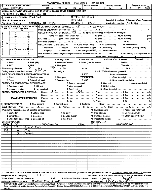
Specific Water Well Detail |
|
|
| Location Info | |||
| Owner: Murfin Drilling Co. | Status: Plugged | ||
| Location: T6S, R26W, Sec. 26, NW SE NW | County: Sheridan | ||
| Directions: from Hoxie: 9 mi N, 13 mi E | |||
| Latitude: 39.5045313 | Longitude: -100.1932955 | Datum NAD 27 | |
| Latitude: 39.5045348 | Longitude: -100.1937082 | Datum NAD 83 | |
| Longitude and latitude calculated by Survey from township-range-section-quarter calls. Only good to within the quarter call accuracy. | |||
| View well on interactive map | |||
| General Info | ||
| Well Depth: 235 ft. | Elevation: ft. | |
| Static Water Level: 159 ft. | Est. Yield: gpm. | |
| Comp. Date: 01-May-1987 | Well Use: Oil Field Water Supply | |
| DWR Applic. #: T84-787 | Other ID: | |
| Driller Info | ||
| Driller: Walter Woofter Pump & Well | License #: 394 | |
| Scanned Form | View scan |
| Casing Info | ||
|
Casing Type:
Diam: 5 in. Casing height above land surface: in | ||
| Grout Info | ||
| Grout used: | From: 0 to 0 ft
From: 0 to 0 ft From: 0 to 0 ft | |
| Source of Possible Contamination | ||
| Source: | ||
| Direction from well: | Distance: 0 ft | |