|
|
|
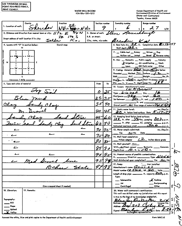
Specific Water Well Detail |
|
|
| Location Info | |||
| Owner: Launchbaugh, Steve | Status: Constructed | ||
| Location: T6S, R27W, Sec. 9, NW SE NW | County: Sheridan | ||
| Directions: from Selden: 11.5 mi E, .75 mi N, 1 mi E, 1.25 mi S | |||
| Latitude: 39.5483171 | Longitude: -100.3420693 | Datum NAD 27 | |
| Latitude: 39.5483208 | Longitude: -100.3424865 | Datum NAD 83 | |
| Longitude and latitude calculated by Survey from township-range-section-quarter calls. Only good to within the quarter call accuracy. | |||
| View well on interactive map | |||
| General Info | ||
| Well Depth: 100 ft. | Elevation: ft. | |
| Static Water Level: 20 ft. | Est. Yield: 300 gpm. | |
| Comp. Date: 12-Mar-1977 | Well Use: Irrigation | |
| DWR Applic. #: | Other ID: | |
| Links | |
| View info from Wizard Water Level Data base... | |
| View info from WIMAS Water Right Data base... | |
| Driller Info | ||
| Driller: Blue Jay Drilling Co., Inc. | License #: 214 | |
| Scanned Form | View scan |
|
Chemical Sample Submitted?: No
Water Well disinfected?: | ||
| Ground water encountered: 0 ft. , 0 ft. , 0 ft. | ||
| Pump test data: Well water was 0 ft after 0 hours pumping 0 gpm | ||
| Casing Info | ||
| Casing Type:
Casing Joints: |
Diam: 0 in. to 0 ft
Diam: 0 in. to 0 ft Diam: 0 in. to 0 ft | |
| Casing height above land surface: in
Casing Weight: lbs/ft Wall thickness or gauge no.: | ||
| Screen and Perforation Info | ||
| Screen Type: | Screen Openings: | |
| Screen-perforated intervals | From: 80 ft to 100 ft
From: 0 ft to 0 ft From: 0 ft to 0 ft | |
| Gravel pack intervals | From: ft to ft | |
| Grout Info | ||
| Grout used: | From: 0 to 0 ft
From: 0 to 0 ft From: 0 to 0 ft | |
| Source of Possible Contamination | ||
| Source: | ||
| Direction from well: | Distance: 0 ft | |
| Lithologic Log
(Log data entered by KGS.) | ||
| From: 0 ft. to 25 ft. | Top soil | |
| From: 25 ft. to 35 ft. | Blue mud | |
| From: 35 ft. to 40 ft. | Clay, sandy clay | |
| From: 40 ft. to 45 ft. | Medium gravel | |
| From: 45 ft. to 60 ft. | Sandy clay, sandstone | |
| From: 60 ft. to 70 ft. | Fine sand, sandy clay, sandstone | |
| From: 70 ft. to 75 ft. | Fine sand, sandstone | |
| From: 75 ft. to 80 ft. | Fine sand, sandy clay, sandstone | |
| From: 80 ft. to 85 ft. | Fine sand | |
| From: 85 ft. to 90 ft. | Fine sand | |
| From: 90 ft. to 95 ft. | Fine sand, sandy clay | |
| From: 95 ft. to 97 ft. | Fine sand, medium gravel loose | |
| From: 97 ft. to 98 ft. | Ochre, shale | |