|
|
|
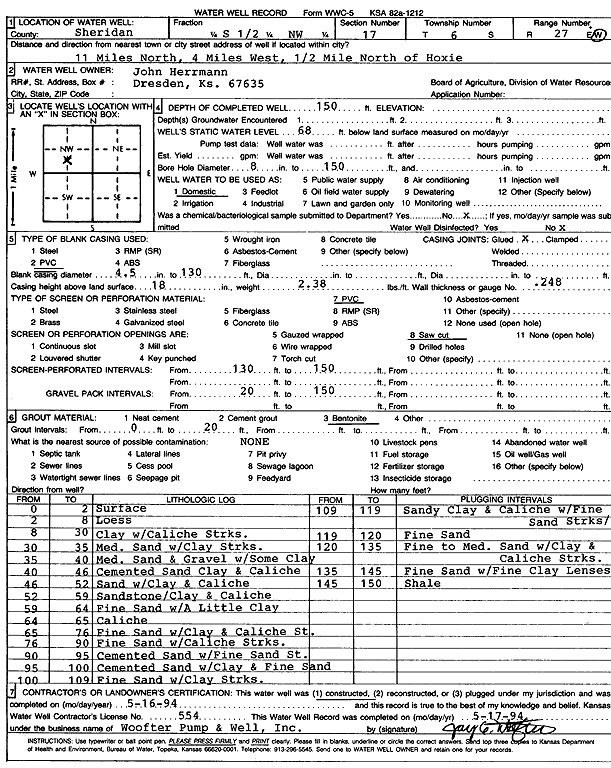
Specific Water Well Detail |
|
|
| Location Info | |||
| Owner: Herrmann, John | Status: Constructed | ||
| Location: T6S, R27W, Sec. 17, S2 NW | County: Sheridan | ||
| Directions: from Hoxie: 11 mi N, 4 mi W, .5 mi N | |||
| Latitude: 39.5329487 | Longitude: -100.3622347 | Datum NAD 27 | |
| Latitude: 39.5329524 | Longitude: -100.3626522 | Datum NAD 83 | |
| Longitude and latitude calculated by Survey from township-range-section-quarter calls. Only good to within the quarter call accuracy. | |||
| View well on interactive map | |||
| General Info | ||
| Well Depth: 150 ft. | Elevation: ft. | |
| Static Water Level: 68 ft. | Est. Yield: gpm. | |
| Comp. Date: 16-May-1994 | Well Use: Domestic | |
| DWR Applic. #: | Other ID: | |
| Driller Info | ||
| Driller: Woofter Pump & Well, Inc. | License #: 554 | |
| Scanned Form | View scan |
|
Chemical Sample Submitted?: No
Water Well disinfected?: | ||
| Ground water encountered: 0 ft. , 0 ft. , 0 ft. | ||
| Pump test data: Well water was 0 ft after 0 hours pumping 0 gpm | ||
| Casing Info | ||
| Casing Type: PVC
Casing Joints: |
Diam: 4 in. to 130 ft
Diam: 0 in. to 0 ft Diam: 0 in. to 0 ft | |
| Casing height above land surface: in
Casing Weight: lbs/ft Wall thickness or gauge no.: | ||
| Screen and Perforation Info | ||
| Screen Type: PVC | Screen Openings: Saw cut | |
| Screen-perforated intervals | From: 130 ft to 150 ft
From: 0 ft to 0 ft From: 0 ft to 0 ft | |
| Gravel pack intervals | From: ft to ft | |
| Grout Info | ||
| Grout used: Bentonite | From: 0 to 20 ft
From: 0 to 0 ft From: 0 to 0 ft | |
| Source of Possible Contamination | ||
| Source: OTHER | ||
| Direction from well: | Distance: 0 ft | |
| Lithologic Log
(Log data entered by KGS.) | ||
| From: 0 ft. to 2 ft. | Surface | |
| From: 2 ft. to 8 ft. | Loess | |
| From: 8 ft. to 30 ft. | Clay with caliche streaks | |
| From: 30 ft. to 35 ft. | Medium sand with clay streaks | |
| From: 35 ft. to 40 ft. | Medium sand and gravel with some clay | |
| From: 40 ft. to 46 ft. | Cemented sand clay and caliche | |
| From: 46 ft. to 52 ft. | Sand with clay and caliche | |
| From: 52 ft. to 59 ft. | Sandstone, clay and caliche | |
| From: 59 ft. to 64 ft. | Fine sand with a little clay | |
| From: 64 ft. to 65 ft. | Caliche | |
| From: 65 ft. to 76 ft. | Fine sand with clay and caliche streak | |
| From: 76 ft. to 90 ft. | Fine sand with caliche streaks | |
| From: 90 ft. to 95 ft. | Cemented sand with fine sand streak | |
| From: 95 ft. to 100 ft. | Cemented sand with clay and fine sand | |
| From: 100 ft. to 109 ft. | Fine sand with clay streaks | |
| From: 109 ft. to 119 ft. | Sandy clay and caliche with fine sand streaks | |
| From: 119 ft. to 120 ft. | Fine sand | |
| From: 120 ft. to 135 ft. | Fine to medium sand with clay and caliche streaks | |
| From: 135 ft. to 145 ft. | Fine sand with fine clay lenses | |
| From: 145 ft. to 150 ft. | Shale | |