|
|
|
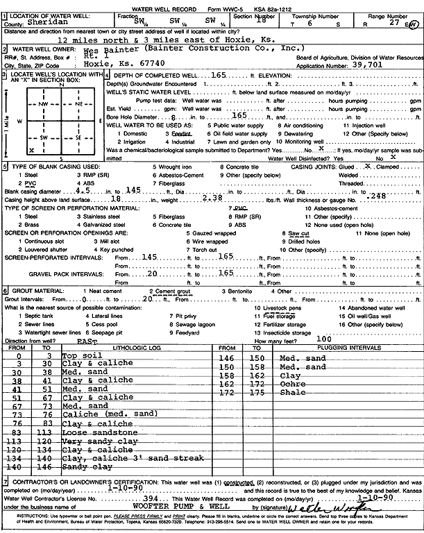
Specific Water Well Detail |
|
|
| Location Info | |||
| Owner: Bainter Construction Co., Inc. | Status: Constructed | ||
| Location: T6S, R27W, Sec. 18, SW SW SW | County: Sheridan | ||
| Directions: from Hoxie: 12 mi N, 3 mi E | |||
| Latitude: 39.524984 | Longitude: -100.3839562 | Datum NAD 27 | |
| Latitude: 39.5249876 | Longitude: -100.384374 | Datum NAD 83 | |
| Longitude and latitude calculated by Survey from township-range-section-quarter calls. Only good to within the quarter call accuracy. | |||
| View well on interactive map | |||
| General Info | ||
| Well Depth: 165 ft. | Elevation: ft. | |
| Static Water Level: ft. | Est. Yield: gpm. | |
| Comp. Date: 10-Jan-1990 | Well Use: Feedlot | |
| DWR Applic. #: 39,701 | Other ID: | |
| Links | |
| No Wizard information available. | |
| View info from WIMAS Water Right Data base... | |
| Driller Info | ||
| Driller: Walter Woofter Pump & Well | License #: 394 | |
| Scanned Form | View scan |
|
Chemical Sample Submitted?: No
Water Well disinfected?: | ||
| Ground water encountered: 0 ft. , 0 ft. , 0 ft. | ||
| Pump test data: Well water was 0 ft after 0 hours pumping 0 gpm | ||
| Casing Info | ||
| Casing Type: PVC
Casing Joints: |
Diam: 4 in. to 145 ft
Diam: 0 in. to 0 ft Diam: 0 in. to 0 ft | |
| Casing height above land surface: in
Casing Weight: lbs/ft Wall thickness or gauge no.: | ||
| Screen and Perforation Info | ||
| Screen Type: PVC | Screen Openings: Saw cut | |
| Screen-perforated intervals | From: 145 ft to 165 ft
From: 0 ft to 0 ft From: 0 ft to 0 ft | |
| Gravel pack intervals | From: ft to ft | |
| Grout Info | ||
| Grout used: Cement grout | From: 0 to 20 ft
From: 0 to 0 ft From: 0 to 0 ft | |
| Source of Possible Contamination | ||
| Source: Livestock pens | ||
| Direction from well: | Distance: 0 ft | |
| Lithologic Log
(Log data entered by KGS.) | ||
| From: 0 ft. to 3 ft. | Top soil | |
| From: 3 ft. to 30 ft. | Clay and caliche | |
| From: 30 ft. to 38 ft. | Medium sand | |
| From: 38 ft. to 41 ft. | Clay | |
| From: 41 ft. to 51 ft. | Medium sand | |
| From: 51 ft. to 67 ft. | Clay and caliche | |
| From: 67 ft. to 73 ft. | Medium sand | |
| From: 73 ft. to 76 ft. | Caliche (medium sand) | |
| From: 76 ft. to 83 ft. | Clay and caliche | |
| From: 83 ft. to 113 ft. | Loose sandstone | |
| From: 113 ft. to 120 ft. | Very sandy clay | |
| From: 120 ft. to 134 ft. | Clay and caliche | |
| From: 134 ft. to 140 ft. | Clay, caliche, and 3-foot sand streak | |
| From: 140 ft. to 146 ft. | Sandy clay | |
| From: 146 ft. to 150 ft. | Medium sand | |
| From: 150 ft. to 158 ft. | Medium sand | |
| From: 158 ft. to 162 ft. | Clay | |
| From: 162 ft. to 172 ft. | Ochre | |
| From: 172 ft. to 175 ft. | Shale | |