|
|
|
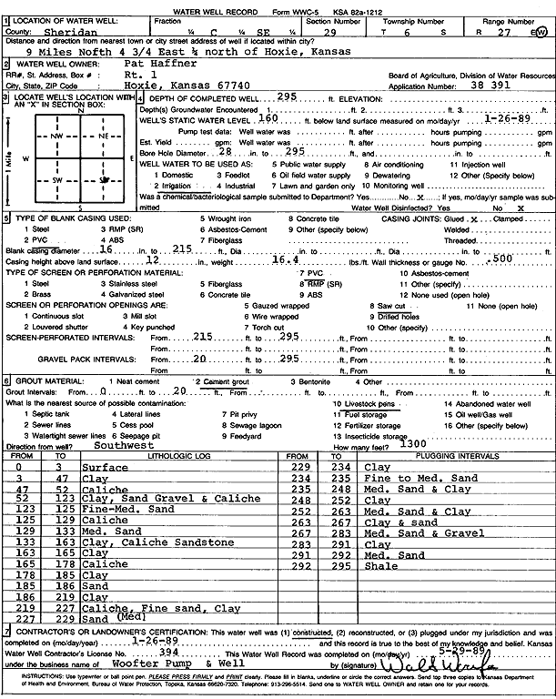
Specific Water Well Detail |
|
|
| Location Info | |||
| Owner: Haffner, Pat | Status: Constructed | ||
| Location: T6S, R27W, Sec. 29, C SE | County: Sheridan | ||
| Directions: from Hoxie: 9 mi N, 4.75 mi E, .25 mi N | |||
| Latitude: 39.4985222 | Longitude: -100.35326 | Datum NAD 27 | |
| Latitude: 39.4985257 | Longitude: -100.3536771 | Datum NAD 83 | |
| Longitude and latitude calculated by Survey from township-range-section-quarter calls. Only good to within the quarter call accuracy. | |||
| View well on interactive map | |||
| General Info | ||
| Well Depth: 295 ft. | Elevation: ft. | |
| Static Water Level: 160 ft. | Est. Yield: gpm. | |
| Comp. Date: 26-Jan-1989 | Well Use: Irrigation | |
| DWR Applic. #: 38391 | Other ID: | |
| Links | |
| No Wizard information available. | |
| View info from WIMAS Water Right Data base... | |
| Driller Info | ||
| Driller: Walter Woofter Pump & Well | License #: 394 | |
| Scanned Form | View scan |
|
Chemical Sample Submitted?: No
Water Well disinfected?: | ||
| Ground water encountered: 0 ft. , 0 ft. , 0 ft. | ||
| Pump test data: Well water was 0 ft after 0 hours pumping 0 gpm | ||
| Casing Info | ||
| Casing Type: PVC
Casing Joints: |
Diam: 16 in. to 215 ft
Diam: 0 in. to 0 ft Diam: 0 in. to 0 ft | |
| Casing height above land surface: in
Casing Weight: lbs/ft Wall thickness or gauge no.: | ||
| Screen and Perforation Info | ||
| Screen Type: PVC | Screen Openings: Saw cut | |
| Screen-perforated intervals | From: 215 ft to 295 ft
From: 0 ft to 0 ft From: 0 ft to 0 ft | |
| Gravel pack intervals | From: ft to ft | |
| Grout Info | ||
| Grout used: Cement grout | From: 0 to 20 ft
From: 0 to 0 ft From: 0 to 0 ft | |
| Source of Possible Contamination | ||
| Source: Livestock pens | ||
| Direction from well: | Distance: 0 ft | |
| Lithologic Log
(Log data entered by KGS.) | ||
| From: 0 ft. to 3 ft. | Surface | |
| From: 3 ft. to 47 ft. | Clay | |
| From: 47 ft. to 52 ft. | Caliche | |
| From: 52 ft. to 123 ft. | Clay, sand gravel and caliche | |
| From: 123 ft. to 125 ft. | Fine to medium sand | |
| From: 125 ft. to 129 ft. | Caliche | |
| From: 129 ft. to 133 ft. | Medium sand | |
| From: 133 ft. to 163 ft. | Clay, caliche sandstone | |
| From: 163 ft. to 165 ft. | Clay | |
| From: 165 ft. to 178 ft. | Caliche | |
| From: 178 ft. to 185 ft. | Clay | |
| From: 185 ft. to 186 ft. | Sand | |
| From: 186 ft. to 219 ft. | Clay | |
| From: 219 ft. to 227 ft. | Caliche, fine sand, clay | |
| From: 227 ft. to 229 ft. | Medium sand | |
| From: 229 ft. to 234 ft. | Clay | |
| From: 234 ft. to 235 ft. | Fine to medium sand | |
| From: 235 ft. to 248 ft. | Medium sand and clay | |
| From: 248 ft. to 252 ft. | Clay | |
| From: 252 ft. to 263 ft. | Medium sand and clay | |
| From: 263 ft. to 267 ft. | Clay and sand | |
| From: 267 ft. to 283 ft. | Medium sand and gravel | |
| From: 283 ft. to 291 ft. | Clay | |
| From: 291 ft. to 292 ft. | Medium sand | |
| From: 292 ft. to 295 ft. | Shale | |