|
|
|
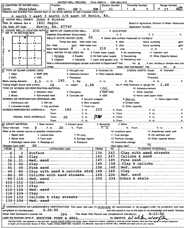
Specific Water Well Detail |
|
|
| Location Info | |||
| Owner: Winter, John S. | Status: Constructed | ||
| Location: T6S, R27W, Sec. 31, NE NE NW | County: Sheridan | ||
| Directions: from Hoxie: 6 mi N, 3 mi E, 3 mi N, .38 mi E | |||
| Latitude: 39.4942049 | Longitude: -100.3774602 | Datum NAD 27 | |
| Latitude: 39.4942085 | Longitude: -100.3778777 | Datum NAD 83 | |
| Longitude and latitude calculated by Survey from township-range-section-quarter calls. Only good to within the quarter call accuracy. | |||
| View well on interactive map | |||
| General Info | ||
| Well Depth: 210 ft. | Elevation: ft. | |
| Static Water Level: 90 ft. | Est. Yield: gpm. | |
| Comp. Date: 20-Apr-1990 | Well Use: Domestic | |
| DWR Applic. #: | Other ID: | |
| Driller Info | ||
| Driller: Walter Woofter Pump & Well | License #: 394 | |
| Scanned Form | View scan |
|
Chemical Sample Submitted?: No
Water Well disinfected?: | ||
| Ground water encountered: 0 ft. , 0 ft. , 0 ft. | ||
| Pump test data: Well water was 0 ft after 0 hours pumping 0 gpm | ||
| Casing Info | ||
| Casing Type: PVC
Casing Joints: |
Diam: 4 in. to 190 ft
Diam: 0 in. to 0 ft Diam: 0 in. to 0 ft | |
| Casing height above land surface: in
Casing Weight: lbs/ft Wall thickness or gauge no.: | ||
| Screen and Perforation Info | ||
| Screen Type: PVC | Screen Openings: Saw cut | |
| Screen-perforated intervals | From: 190 ft to 210 ft
From: 0 ft to 0 ft From: 0 ft to 0 ft | |
| Gravel pack intervals | From: ft to ft | |
| Grout Info | ||
| Grout used: Bentonite | From: 0 to 20 ft
From: 0 to 0 ft From: 0 to 0 ft | |
| Source of Possible Contamination | ||
| Source: OTHER | ||
| Direction from well: | Distance: 0 ft | |
| Lithologic Log
(Log data entered by KGS.) | ||
| From: 0 ft. to 3 ft. | Surface | |
| From: 3 ft. to 26 ft. | Clay | |
| From: 26 ft. to 31 ft. | Medium sand | |
| From: 31 ft. to 45 ft. | Clay | |
| From: 45 ft. to 49 ft. | Fine sand | |
| From: 49 ft. to 80 ft. | Clay with sand and caliche streak | |
| From: 80 ft. to 99 ft. | Caliche with sand streak | |
| From: 99 ft. to 110 ft. | Medium sand | |
| From: 110 ft. to 111 ft. | Caliche | |
| From: 111 ft. to 112 ft. | Clay | |
| From: 112 ft. to 118 ft. | Medium sand | |
| From: 118 ft. to 124 ft. | Clay | |
| From: 124 ft. to 132 ft. | Caliche and clay streaks | |
| From: 132 ft. to 134 ft. | Medium sand | |
| From: 134 ft. to 142 ft. | Clay with sand streaks | |
| From: 142 ft. to 147 ft. | Caliche and sand | |
| From: 147 ft. to 149 ft. | Fine sand | |
| From: 149 ft. to 158 ft. | Clay and caliche | |
| From: 159 ft. to 168 ft. | Medium sand | |
| From: 168 ft. to 169 ft. | Clay | |
| From: 169 ft. to 230 ft. | Medium sand | |
| From: 230 ft. to 234 ft. | Ochre and shale | |