|
|
|
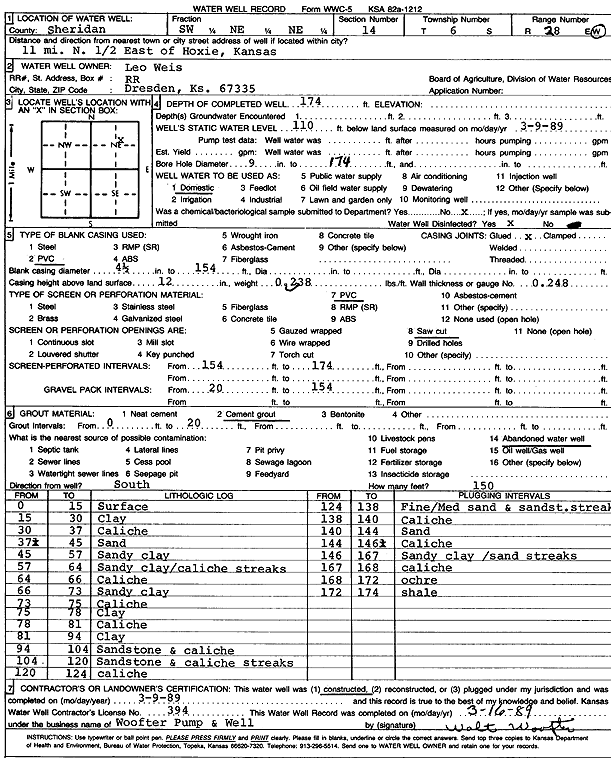
Specific Water Well Detail |
|
|
| Location Info | |||
| Owner: Weis, Leo | Status: Constructed | ||
| Location: T6S, R28W, Sec. 14, SW NE NE | County: Sheridan | ||
| Directions: from Hoxie: 11 mi N, .5 mi E | |||
| Latitude: 39.5359565 | Longitude: -100.4072083 | Datum NAD 27 | |
| Latitude: 39.5359602 | Longitude: -100.4076266 | Datum NAD 83 | |
| Longitude and latitude calculated by Survey from township-range-section-quarter calls. Only good to within the quarter call accuracy. | |||
| View well on interactive map | |||
| General Info | ||
| Well Depth: 174 ft. | Elevation: ft. | |
| Static Water Level: 110 ft. | Est. Yield: gpm. | |
| Comp. Date: 09-Mar-1989 | Well Use: Domestic | |
| DWR Applic. #: | Other ID: | |
| Driller Info | ||
| Driller: Walter Woofter Pump & Well | License #: 394 | |
| Scanned Form | View scan |
|
Chemical Sample Submitted?: No
Water Well disinfected?: | ||
| Ground water encountered: 0 ft. , 0 ft. , 0 ft. | ||
| Pump test data: Well water was 0 ft after 0 hours pumping 0 gpm | ||
| Casing Info | ||
| Casing Type: PVC
Casing Joints: |
Diam: 4 in. to 154 ft
Diam: 0 in. to 0 ft Diam: 0 in. to 0 ft | |
| Casing height above land surface: in
Casing Weight: lbs/ft Wall thickness or gauge no.: | ||
| Screen and Perforation Info | ||
| Screen Type: PVC | Screen Openings: Saw cut | |
| Screen-perforated intervals | From: 154 ft to 174 ft
From: 0 ft to 0 ft From: 0 ft to 0 ft | |
| Gravel pack intervals | From: ft to ft | |
| Grout Info | ||
| Grout used: Cement grout | From: 0 to 20 ft
From: 0 to 0 ft From: 0 to 0 ft | |
| Source of Possible Contamination | ||
| Source: Abandoned water well | ||
| Direction from well: | Distance: 0 ft | |
| Lithologic Log
(Log data entered by KGS.) | ||
| From: 0 ft. to 15 ft. | Surface | |
| From: 15 ft. to 30 ft. | Clay | |
| From: 30 ft. to 37 ft. | Caliche | |
| From: 37 ft. to 45 ft. | Sand | |
| From: 45 ft. to 57 ft. | Sandy clay | |
| From: 57 ft. to 64 ft. | Sandy clay, caliche streaks | |
| From: 64 ft. to 66 ft. | Caliche | |
| From: 66 ft. to 73 ft. | Sandy clay | |
| From: 73 ft. to 75 ft. | Caliche | |
| From: 75 ft. to 78 ft. | Clay | |
| From: 78 ft. to 81 ft. | Caliche | |
| From: 81 ft. to 94 ft. | Clay | |
| From: 94 ft. to 104 ft. | Sandstone and caliche | |
| From: 104 ft. to 120 ft. | Sandstone and caliche streaks | |
| From: 120 ft. to 124 ft. | Caliche | |
| From: 124 ft. to 138 ft. | Fine to medium sand and sandstone streak | |
| From: 138 ft. to 140 ft. | Caliche | |
| From: 140 ft. to 144 ft. | Sand | |
| From: 144 ft. to 146 ft. | Caliche | |
| From: 146 ft. to 167 ft. | Sandy clay, sand streaks | |
| From: 167 ft. to 168 ft. | Caliche | |
| From: 168 ft. to 172 ft. | Ochre | |
| From: 172 ft. to 174 ft. | Shale | |