|
|
|
Specific Water Well Detail |
|
|
| Location Info | |||
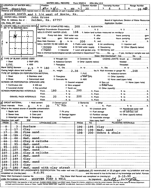
| Owner: Kruse, John | Status: Constructed | ||
| Location: T6S, R28W, Sec. 20, NW | County: Sheridan | ||
| Directions: from Hoxie: 11 mi N, 1.75 mi W | |||
| Latitude: 39.520383 | Longitude: -100.4738386 | Datum NAD 27 | |
| Latitude: 39.5203868 | Longitude: -100.4742581 | Datum NAD 83 | |
| Longitude and latitude calculated by Survey from township-range-section-quarter calls. Only good to within the quarter call accuracy. | |||
| View well on interactive map | |||
| General Info | ||
| Well Depth: 200 ft. | Elevation: ft. | |
| Static Water Level: 108 ft. | Est. Yield: gpm. | |
| Comp. Date: 06-Sep-1990 | Well Use: Domestic | |
| DWR Applic. #: | Other ID: | |
| Driller Info | ||
| Driller: Walter Woofter Pump & Well | License #: 394 | |
| Scanned Form | View scan |
|
Chemical Sample Submitted?: No
Water Well disinfected?: | ||
| Ground water encountered: 0 ft. , 0 ft. , 0 ft. | ||
| Pump test data: Well water was 0 ft after 0 hours pumping 0 gpm | ||
| Casing Info | ||
| Casing Type: PVC
Casing Joints: |
Diam: 4 in. to 180 ft
Diam: 0 in. to 0 ft Diam: 0 in. to 0 ft | |
| Casing height above land surface: in
Casing Weight: lbs/ft Wall thickness or gauge no.: | ||
| Screen and Perforation Info | ||
| Screen Type: PVC | Screen Openings: Saw cut | |
| Screen-perforated intervals | From: 180 ft to 200 ft
From: 0 ft to 0 ft From: 0 ft to 0 ft | |
| Gravel pack intervals | From: ft to ft | |
| Grout Info | ||
| Grout used: Cement grout | From: 0 to 20 ft
From: 0 to 0 ft From: 0 to 0 ft | |
| Source of Possible Contamination | ||
| Source: Abandoned water well | ||
| Direction from well: | Distance: 0 ft | |
| Lithologic Log
(Log data entered by KGS.) | ||
| From: 0 ft. to 3 ft. | Surface | |
| From: 3 ft. to 17 ft. | Clay | |
| From: 17 ft. to 38 ft. | Fine sand | |
| From: 38 ft. to 59 ft. | Clay | |
| From: 59 ft. to 66 ft. | Medium clay | |
| From: 66 ft. to 92 ft. | Clay and caliche | |
| From: 92 ft. to 95 ft. | Medium sand | |
| From: 95 ft. to 101 ft. | Clay and caliche | |
| From: 101 ft. to 107 ft. | Medium sand | |
| From: 107 ft. to 130 ft. | Clay and caliche | |
| From: 130 ft. to 147 ft. | Medium sand | |
| From: 147 ft. to 149 ft. | Clay | |
| From: 149 ft. to 164 ft. | Medium sand | |
| From: 164 ft. to 173 ft. | Clay | |
| From: 173 ft. to 190 ft. | Medium sand with clay streaks | |
| From: 190 ft. to 195 ft. | Clay | |
| From: 195 ft. to 198 ft. | Medium sand | |
| From: 198 ft. to 200 ft. | Ochre and shale | |