|
|
|
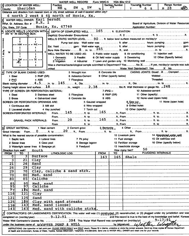
Specific Water Well Detail |
|
|
| Location Info | |||
| Owner: Berndt, Karl | Status: Constructed | ||
| Location: T6S, R28W, Sec. 29, NE SW SW | County: Sheridan | ||
| Directions: from Hoxie: 6 mi N, 2 mi W, 4.5 mi N | |||
| Latitude: 39.497936 | Longitude: -100.4751256 | Datum NAD 27 | |
| Latitude: 39.4979398 | Longitude: -100.4755451 | Datum NAD 83 | |
| Longitude and latitude calculated by Survey from township-range-section-quarter calls. Only good to within the quarter call accuracy. | |||
| View well on interactive map | |||
| General Info | ||
| Well Depth: 165 ft. | Elevation: ft. | |
| Static Water Level: 90 ft. | Est. Yield: gpm. | |
| Comp. Date: 12-Sep-1991 | Well Use: Domestic | |
| DWR Applic. #: | Other ID: | |
| Driller Info | ||
| Driller: Walter Woofter Pump & Well | License #: 394 | |
| Scanned Form | View scan |
|
Chemical Sample Submitted?: No
Water Well disinfected?: | ||
| Ground water encountered: 0 ft. , 0 ft. , 0 ft. | ||
| Pump test data: Well water was 0 ft after 0 hours pumping 0 gpm | ||
| Casing Info | ||
| Casing Type: PVC
Casing Joints: |
Diam: 4 in. to 145 ft
Diam: 0 in. to 0 ft Diam: 0 in. to 0 ft | |
| Casing height above land surface: in
Casing Weight: lbs/ft Wall thickness or gauge no.: | ||
| Screen and Perforation Info | ||
| Screen Type: PVC | Screen Openings: Saw cut | |
| Screen-perforated intervals | From: 145 ft to 165 ft
From: 0 ft to 0 ft From: 0 ft to 0 ft | |
| Gravel pack intervals | From: ft to ft | |
| Grout Info | ||
| Grout used: Bentonite | From: 0 to 20 ft
From: 0 to 0 ft From: 0 to 0 ft | |
| Source of Possible Contamination | ||
| Source: Abandoned water well | ||
| Direction from well: | Distance: 0 ft | |
| Lithologic Log
(Log data entered by KGS.) | ||
| From: 0 ft. to 3 ft. | Surface | |
| From: 3 ft. to 21 ft. | Clay | |
| From: 21 ft. to 26 ft. | Sand | |
| From: 26 ft. to 29 ft. | Clay | |
| From: 29 ft. to 70 ft. | Clay, caliche and sand streaks | |
| From: 70 ft. to 80 ft. | Medium sand | |
| From: 80 ft. to 85 ft. | Caliche | |
| From: 85 ft. to 95 ft. | Medium sand | |
| From: 95 ft. to 97 ft. | Caliche | |
| From: 97 ft. to 116 ft. | Medium sand | |
| From: 116 ft. to 121 ft. | Clay | |
| From: 121 ft. to 125 ft. | Sand | |
| From: 125 ft. to 139 ft. | Clay with sand streaks | |
| From: 139 ft. to 143 ft. | Medium sand (loose) | |
| From: 143 ft. to 163 ft. | Medium sand with caliche streaks | |
| From: 163 ft. to 165 ft. | Shale | |