|
|
|
Specific Water Well Detail |
|
|
| Location Info | |||
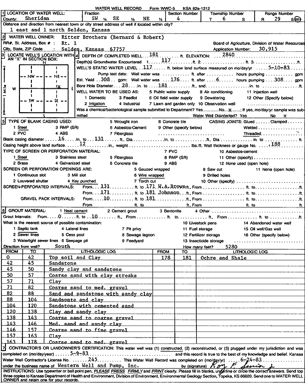
| Owner: Ritter Brothers | Status: Constructed | ||
| Location: T6S, R29W, Sec. 4, SW SE NE | County: Sheridan | ||
| Directions: from Selden: 1 mi E, 1 mi N | |||
| Latitude: 39.5614285 | Longitude: -100.5557482 | Datum NAD 27 | |
| Latitude: 39.5614358 | Longitude: -100.5561699 | Datum NAD 83 | |
| Longitude and latitude calculated by Survey from township-range-section-quarter calls. Only good to within the quarter call accuracy. | |||
| View well on interactive map | |||
| General Info | ||
| Well Depth: 181 ft. | Elevation: 2840 ft. | |
| Static Water Level: 117 ft. | Est. Yield: 308 gpm. | |
| Comp. Date: 09-May-1983 | Well Use: Irrigation | |
| DWR Applic. #: 30915 | Other ID: | |
| Links | |
| No Wizard information available. | |
| View info from WIMAS Water Right Data base... | |
| Driller Info | ||
| Driller: Western Well & Pump, Inc. | License #: 245 | |
| Scanned Form | View scan |
|
Chemical Sample Submitted?: No
Water Well disinfected?: | ||
| Ground water encountered: 0 ft. , 0 ft. , 0 ft. | ||
| Pump test data: Well water was 0 ft after 0 hours pumping 0 gpm | ||
| Casing Info | ||
| Casing Type:
Casing Joints: |
Diam: 0 in. to 0 ft
Diam: 0 in. to 0 ft Diam: 0 in. to 0 ft | |
| Casing height above land surface: in
Casing Weight: lbs/ft Wall thickness or gauge no.: | ||
| Screen and Perforation Info | ||
| Screen Type: | Screen Openings: | |
| Screen-perforated intervals | From: 131 ft to 171 ft
From: 171 ft to 181 ft From: 0 ft to 0 ft | |
| Gravel pack intervals | From: ft to ft | |
| Grout Info | ||
| Grout used: | From: 0 to 0 ft
From: 0 to 0 ft From: 0 to 0 ft | |
| Source of Possible Contamination | ||
| Source: | ||
| Direction from well: | Distance: 0 ft | |
| Lithologic Log
(Log data entered by KGS.) | ||
| From: 0 ft. to 42 ft. | Top soil and clay | |
| From: 42 ft. to 45 ft. | Sandstone | |
| From: 45 ft. to 50 ft. | Sandy clay and sandstone | |
| From: 50 ft. to 57 ft. | Coarse sand with clay streaks | |
| From: 57 ft. to 71 ft. | Clay | |
| From: 71 ft. to 82 ft. | Coarse sand to medium gravel | |
| From: 82 ft. to 88 ft. | Sand and sandstone with sandy clay | |
| From: 88 ft. to 104 ft. | Sandstone and clay | |
| From: 104 ft. to 120 ft. | Sandstone with cemented sand | |
| From: 120 ft. to 138 ft. | Clay and sandy clay | |
| From: 138 ft. to 143 ft. | Coarse sand to coarse gravel | |
| From: 143 ft. to 146 ft. | Medium sand and sandy clay | |
| From: 146 ft. to 157 ft. | Coarse sand to fine gravel | |
| From: 157 ft. to 163 ft. | Clay | |
| From: 163 ft. to 178 ft. | Coarse sand to medium gravel | |
| From: 178 ft. to 181 ft. | Ochre and shale | |