|
|
|
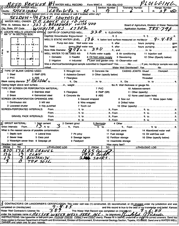
Specific Water Well Detail |
|
|
| Location Info | |||
| Owner: D. R. Lauck Oil Co. | Status: Plugged | ||
| Location: T6S, R29W, Sec. 9, C E2 W2 SE | County: Sheridan | ||
| Directions: from Selden: .25 mi E, S side | |||
| Latitude: 39.5422566 | Longitude: -100.558404 | Datum NAD 27 | |
| Latitude: 39.5422606 | Longitude: -100.5588257 | Datum NAD 83 | |
| Longitude and latitude calculated by Survey from township-range-section-quarter calls. Only good to within the quarter call accuracy. | |||
| View well on interactive map | |||
| General Info | ||
| Well Depth: 220 ft. | Elevation: ft. | |
| Static Water Level: 136 ft. | Est. Yield: gpm. | |
| Comp. Date: 04-Sep-1985 | Well Use: Oil Field Water Supply | |
| DWR Applic. #: T85-790 | Other ID: Reed Parker 1 | |
| Driller Info | ||
| Driller: Rudolph J. Reiser Water Well Service, Inc. | License #: 389 | |
| Scanned Form | View scan |
| Casing Info | ||
|
Casing Type:
Diam: 0 in. Casing height above land surface: in | ||
| Grout Info | ||
| Grout used: Bentonite | From: 13 to 3 ft
From: 0 to 0 ft From: 0 to 0 ft | |
| Source of Possible Contamination | ||
| Source: | ||
| Direction from well: | Distance: 0 ft | |