|
|
|
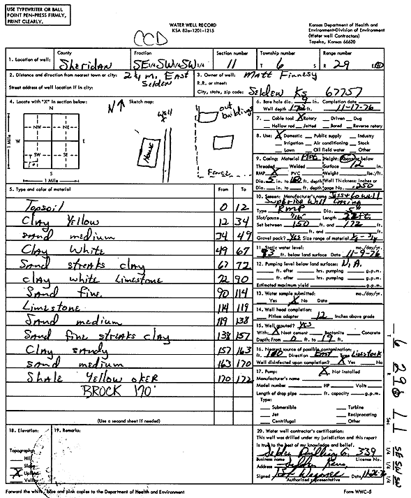
Specific Water Well Detail |
|
|
| Location Info | |||
| Owner: Finnesy, Matt | Status: Constructed | ||
| Location: T6S, R29W, Sec. 11, SE SW SW | County: Sheridan | ||
| Directions: from Selden: 2.25 mi E | |||
| Latitude: 39.5395926 | Longitude: -100.5303482 | Datum NAD 27 | |
| Latitude: 39.5395965 | Longitude: -100.5307692 | Datum NAD 83 | |
| Longitude and latitude calculated by Survey from township-range-section-quarter calls. Only good to within the quarter call accuracy. | |||
| View well on interactive map | |||
| General Info | ||
| Well Depth: 172 ft. | Elevation: ft. | |
| Static Water Level: 93 ft. | Est. Yield: gpm. | |
| Comp. Date: 17-Nov-1976 | Well Use: Domestic | |
| DWR Applic. #: | Other ID: | |
| Driller Info | ||
| Driller: Seldon Drilling Co., Inc. | License #: 339 | |
| Scanned Form | View scan |
|
Chemical Sample Submitted?: No
Water Well disinfected?: | ||
| Ground water encountered: 0 ft. , 0 ft. , 0 ft. | ||
| Pump test data: Well water was 0 ft after 0 hours pumping 0 gpm | ||
| Casing Info | ||
| Casing Type:
Casing Joints: |
Diam: 0 in. to 0 ft
Diam: 0 in. to 0 ft Diam: 0 in. to 0 ft | |
| Casing height above land surface: in
Casing Weight: lbs/ft Wall thickness or gauge no.: | ||
| Screen and Perforation Info | ||
| Screen Type: | Screen Openings: | |
| Screen-perforated intervals | From: 150 ft to 172 ft
From: 0 ft to 0 ft From: 0 ft to 0 ft | |
| Gravel pack intervals | From: ft to ft | |
| Grout Info | ||
| Grout used: | From: 0 to 0 ft
From: 0 to 0 ft From: 0 to 0 ft | |
| Source of Possible Contamination | ||
| Source: | ||
| Direction from well: | Distance: 0 ft | |
| Lithologic Log
(Log data entered by KGS.) | ||
| From: 0 ft. to 12 ft. | Top soil | |
| From: 12 ft. to 34 ft. | Clay yellow | |
| From: 34 ft. to 49 ft. | Sand medium | |
| From: 49 ft. to 67 ft. | Clay white | |
| From: 67 ft. to 72 ft. | Sand streaks clay | |
| From: 75 ft. to 90 ft. | Clay white limestone | |
| From: 90 ft. to 114 ft. | Sand fine | |
| From: 114 ft. to 119 ft. | Limestone | |
| From: 119 ft. to 138 ft. | Sand medium | |
| From: 138 ft. to 157 ft. | Sand fine streaks clay | |
| From: 157 ft. to 163 ft. | Clay sandy | |
| From: 163 ft. to 170 ft. | Sand medium | |
| From: 170 ft. to 172 ft. | Shale yellow ochre | |