|
|
|
Specific Water Well Detail |
|
|
| Location Info | |||
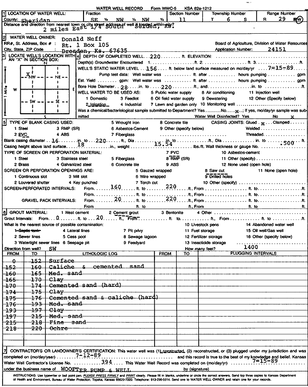
| Owner: Neff, Donald | Status: Constructed | ||
| Location: T6S, R29W, Sec. 11, SE NW NW | County: Sheridan | ||
| Directions: from Selden: 2 mi E, .25 mi S | |||
| Latitude: 39.5504188 | Longitude: -100.5301533 | Datum NAD 27 | |
| Latitude: 39.5504229 | Longitude: -100.5305744 | Datum NAD 83 | |
| Longitude and latitude calculated by Survey from township-range-section-quarter calls. Only good to within the quarter call accuracy. | |||
| View well on interactive map | |||
| General Info | ||
| Well Depth: 220 ft. | Elevation: ft. | |
| Static Water Level: 156 ft. | Est. Yield: gpm. | |
| Comp. Date: 12-Jul-1989 | Well Use: Irrigation | |
| DWR Applic. #: 24151 | Other ID: | |
| Links | |
| No Wizard information available. | |
| View info from WIMAS Water Right Data base... | |
| Driller Info | ||
| Driller: Walter Woofter Pump & Well | License #: 394 | |
| Scanned Form | View scan |
|
Chemical Sample Submitted?: No
Water Well disinfected?: | ||
| Ground water encountered: 0 ft. , 0 ft. , 0 ft. | ||
| Pump test data: Well water was 0 ft after 0 hours pumping 0 gpm | ||
| Casing Info | ||
| Casing Type: PVC
Casing Joints: |
Diam: 16 in. to 220 ft
Diam: 0 in. to 0 ft Diam: 0 in. to 0 ft | |
| Casing height above land surface: in
Casing Weight: lbs/ft Wall thickness or gauge no.: | ||
| Screen and Perforation Info | ||
| Screen Type: PVC | Screen Openings: Saw cut | |
| Screen-perforated intervals | From: 160 ft to 220 ft
From: 0 ft to 0 ft From: 0 ft to 0 ft | |
| Gravel pack intervals | From: ft to ft | |
| Grout Info | ||
| Grout used: Cement grout | From: 0 to 20 ft
From: 0 to 0 ft From: 0 to 0 ft | |
| Source of Possible Contamination | ||
| Source: Septic Tank | ||
| Direction from well: | Distance: 0 ft | |
| Lithologic Log
(Log data entered by KGS.) | ||
| From: 0 ft. to 152 ft. | Surface | |
| From: 152 ft. to 160 ft. | Caliche and cemented sand | |
| From: 160 ft. to 165 ft. | Medium sand | |
| From: 165 ft. to 170 ft. | Clay | |
| From: 170 ft. to 174 ft. | Cemented sand (hard) | |
| From: 174 ft. to 175 ft. | Clay | |
| From: 175 ft. to 176 ft. | Cemented sand and caliche (hard) | |
| From: 176 ft. to 193 ft. | Medium sand | |
| From: 193 ft. to 197 ft. | Clay | |
| From: 197 ft. to 215 ft. | Medium sand | |
| From: 215 ft. to 218 ft. | Fine sand | |
| From: 218 ft. to 220 ft. | Ochre | |