|
|
|
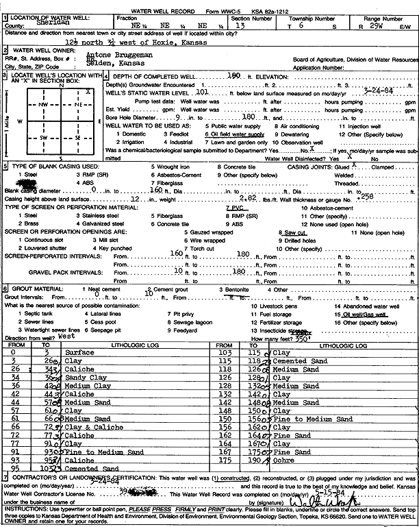
Specific Water Well Detail |
|
|
| Location Info | |||
| Owner: Bruggeman, Antone | Status: Constructed | ||
| Location: T6S, R29W, Sec. 13, NE NE NE | County: Sheridan | ||
| Directions: from Hoxie: 12.5 mi N, 3.25 mi W | |||
| Latitude: 39.5375613 | Longitude: -100.4978134 | Datum NAD 27 | |
| Latitude: 39.5375653 | Longitude: -100.4982335 | Datum NAD 83 | |
| Longitude and latitude calculated by Survey from township-range-section-quarter calls. Only good to within the quarter call accuracy. | |||
| View well on interactive map | |||
| General Info | ||
| Well Depth: 180 ft. | Elevation: ft. | |
| Static Water Level: 101 ft. | Est. Yield: gpm. | |
| Comp. Date: 24-Mar-1984 | Well Use: Oil Field Water Supply | |
| DWR Applic. #: | Other ID: | |
| Driller Info | ||
| Driller: Walter Woofter Pump & Well | License #: 394 | |
| Scanned Form | View scan |
|
Chemical Sample Submitted?: No
Water Well disinfected?: | ||
| Ground water encountered: 0 ft. , 0 ft. , 0 ft. | ||
| Pump test data: Well water was 0 ft after 0 hours pumping 0 gpm | ||
| Casing Info | ||
| Casing Type: PVC
Casing Joints: |
Diam: 0 in. to 160 ft
Diam: 0 in. to 0 ft Diam: 0 in. to 0 ft | |
| Casing height above land surface: in
Casing Weight: lbs/ft Wall thickness or gauge no.: | ||
| Screen and Perforation Info | ||
| Screen Type: PVC | Screen Openings: Saw cut | |
| Screen-perforated intervals | From: 160 ft to 180 ft
From: 0 ft to 0 ft From: 0 ft to 0 ft | |
| Gravel pack intervals | From: ft to ft | |
| Grout Info | ||
| Grout used: Bentonite | From: 0 to 10 ft
From: 0 to 0 ft From: 0 to 0 ft | |
| Source of Possible Contamination | ||
| Source: Oil well/gas well | ||
| Direction from well: | Distance: 0 ft | |
| Lithologic Log
(Log data entered by KGS.) | ||
| From: 0 ft. to 3 ft. | Surface | |
| From: 3 ft. to 26 ft. | Clay | |
| From: 26 ft. to 34 ft. | Caliche | |
| From: 34 ft. to 36 ft. | Sandy clay | |
| From: 36 ft. to 42 ft. | Medium clay | |
| From: 42 ft. to 44 ft. | Caliche | |
| From: 44 ft. to 57 ft. | Medium sand | |
| From: 57 ft. to 61 ft. | Clay | |
| From: 61 ft. to 66 ft. | Medium sand | |
| From: 66 ft. to 72 ft. | Clay and caliche | |
| From: 72 ft. to 77 ft. | Caliche | |
| From: 77 ft. to 91 ft. | Clay | |
| From: 91 ft. to 93 ft. | Fine to medium sand | |
| From: 93 ft. to 95 ft. | Caliche | |
| From: 95 ft. to 103 ft. | Cemented sand | |
| From: 103 ft. to 115 ft. | Clay | |
| From: 115 ft. to 118 ft. | Cemented sand | |
| From: 118 ft. to 126 ft. | Medium sand | |
| From: 126 ft. to 128 ft. | Clay | |
| From: 128 ft. to 132 ft. | Medium sand | |
| From: 132 ft. to 142 ft. | Clay | |
| From: 142 ft. to 148 ft. | Medium sand | |
| From: 148 ft. to 150 ft. | Clay | |
| From: 150 ft. to 156 ft. | Fine to medium sand | |
| From: 156 ft. to 162 ft. | Clay | |
| From: 162 ft. to 164 ft. | Fine sand | |
| From: 164 ft. to 167 ft. | Clay | |
| From: 167 ft. to 175 ft. | Fine sand | |
| From: 175 ft. to 190 ft. | Ochre | |