|
|
|
Specific Water Well Detail |
|
|
| Location Info | |||
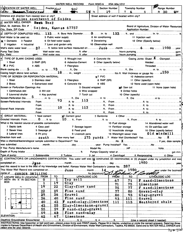
| Owner: Teel, Herb | Status: Constructed | ||
| Location: T6S, R30W, Sec. 19, SW SW SW | County: Sheridan | ||
| Directions: from Selden: 9 mi SW | |||
| Latitude: 39.5112912 | Longitude: -100.7186004 | Datum NAD 27 | |
| Latitude: 39.5112951 | Longitude: -100.7190259 | Datum NAD 83 | |
| Longitude and latitude calculated by Survey from township-range-section-quarter calls. Only good to within the quarter call accuracy. | |||
| View well on interactive map | |||
| General Info | ||
| Well Depth: 113 ft. | Elevation: ft. | |
| Static Water Level: 27 ft. | Est. Yield: gpm. | |
| Comp. Date: 06-Jun-1980 | Well Use: Domestic | |
| DWR Applic. #: | Other ID: | |
| Driller Info | ||
| Driller: Stephen E. Corder Pump & Well | License #: 387 | |
| Scanned Form | View scan |
|
Chemical Sample Submitted?: No
Water Well disinfected?: | ||
| Ground water encountered: 0 ft. , 0 ft. , 0 ft. | ||
| Pump test data: Well water was 0 ft after 0 hours pumping 0 gpm | ||
| Casing Info | ||
| Casing Type:
Casing Joints: |
Diam: 0 in. to 0 ft
Diam: 0 in. to 0 ft Diam: 0 in. to 0 ft | |
| Casing height above land surface: in
Casing Weight: lbs/ft Wall thickness or gauge no.: | ||
| Screen and Perforation Info | ||
| Screen Type: | Screen Openings: | |
| Screen-perforated intervals | From: 93 ft to 113 ft
From: 0 ft to 0 ft From: 0 ft to 0 ft | |
| Gravel pack intervals | From: ft to ft | |
| Grout Info | ||
| Grout used: | From: 0 to 0 ft
From: 0 to 0 ft From: 0 to 0 ft | |
| Source of Possible Contamination | ||
| Source: | ||
| Direction from well: | Distance: 0 ft | |
| Lithologic Log
(Log data entered by KGS.) | ||
| From: 0 ft. to 1 ft. | Top soil | |
| From: 1 ft. to 19 ft. | Clay | |
| From: 19 ft. to 22 ft. | Clay, fine sand | |
| From: 22 ft. to 29 ft. | Fine sand | |
| From: 29 ft. to 36 ft. | Gravel | |
| From: 36 ft. to 40 ft. | Fine sand | |
| From: 40 ft. to 43 ft. | Fine sand, clay, limestone | |
| From: 43 ft. to 55 ft. | Clay, limestone, gravel | |
| From: 55 ft. to 59 ft. | Fine sand, clay, gravel | |
| From: 59 ft. to 62 ft. | Fine sand, clay | |
| From: 62 ft. to 67 ft. | Limestone | |
| From: 67 ft. to 71 ft. | Fine sand, limestone | |
| From: 71 ft. to 75 ft. | Limestone | |
| From: 75 ft. to 77 ft. | Fine sand | |
| From: 77 ft. to 80 ft. | Gravel, clay | |
| From: 80 ft. to 93 ft. | Clay, gravel | |
| From: 93 ft. to 111 ft. | Gravel | |
| From: 111 ft. to 113 ft. | Weathered shale | |